IMAGES TAKEN NEAR TO
Trewince Lane, TRURO, TR2 4DX
Introduction
This page details the photographs taken nearby to Trewince Lane, TR2 4DX by members of the Geograph project.
The Geograph project started in 2005 with the aim of publishing, organising and preserving representative images for every square kilometre of Great Britain, Ireland and the Isle of Man.

There are currently over 7.5m images from over14,400 individuals and you can help contribute to the project by visiting https://www.geograph.org.uk
Image Map
Images are licensed for reuse under creativecommons.org/licenses/by-sa/2.0
Notes
- Clicking on the map will re-center to the selected point.
- The higher the marker number, the further away the image location is from the centre of the postcode.
Image Listing (19 Images Found)
Images are licensed for reuse under creativecommons.org/licenses/by-sa/2.0
Image
Details
Distance
2

City of Truro returns to Truro
A VIP special from Plymouth to Truro was run to mark the completion of the dualling of the railway track from Probus to Burngullow. Of course prior to the 1980s it had been dual track anyway but then the bean counting accountants who ran the railway decided they could save a few quid by making the railway single line between these points. 20 plus years later it cost millions to put the track back again ! Here 3440 is seen from the fence top steaming under the bridge at Grampound Road.
Image: © roger geach
Taken: 30 Nov 2004
0.11 miles
3
Site of Grampound Road station
View SW, towards Truro and Penzance: ex-GWR Plymouth - Penzance main line. The station was, which was behind the camera, closed 5/10/64 but the line has of course survived, although singled on this stretch at that time - but doubled again more recently.
Image: © Ben Brooksbank
Taken: 22 Apr 1995
0.11 miles
4
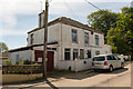
The Old Grampound Road Post Office
Now a private house but proud to have the been the 'old' Post Office in the Village of Grampound Road.
Image: © Mike Lyne
Taken: 26 May 2020
0.12 miles
5
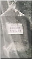
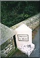
Old Milestone by South Street, Grampound Road village
Metal plate attached to stone post by the UC road, in parish of LADOCK (CARRICK District), Grampound Road, at East end of railway bridge, on North side of road. Grampound iron plate, erected by the Local Highways Board in the 19th century.
Inscription reads:-
: TREGONY/ 4¼ MILES : : BLUE / ANCHOR / 5 MILES :
(replica plate 2012)
Cornwall & Scilly HER.
HER Number: 177603
Milestone Society National ID: CW_TGGP04a.
Image: © Paul Barnett
Taken: 4 Jan 2023
0.12 miles
6
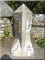
Old Milestone in Grampound Road village
Metal plates attached to stone post by the UC road, in parish of LADOCK (CARRICK District), Grampound Road, at East end of railway bridge, on North side of road. Grampound iron plate, erected by the Local Highways Board in the 19th century.
Inscription reads:-
: TREGONY/ 4¼ MILES : : BLUE / ANCHOR / 5 MILES :
(replica plate 2012)
Milestone Society National ID: CW_TGGP04a.
Image: © Ian Thompson
Taken: 1 Jan 1998
0.12 miles
7
Old Milestone by South Street, Grampound Road village
Metal plate attached to stone post by the UC road, in parish of LADOCK (CARRICK District), Grampound Road, at East end of railway bridge, on North side of road. Grampound iron plate, erected by the Local Highways Board in the 19th century.
Inscription reads:-
: TREGONY/ 4¼ MILES : : BLUE / ANCHOR / 5 MILES :
(replica plate 2012)
Cornwall & Scilly HER.
HER Number: 177603 https://www.heritagegateway.org.uk/Gateway/Results_Single.aspx?uid=MCO53389&resourceID=1020
Milestone Society National ID: CW_TGGP04a.
Image: © Rosy Hanns
Taken: 13 Apr 2019
0.12 miles
8
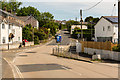
Traffic pinch point
A Traffic pinch point in the middle of Grampound Road village to slow the traffic down through the village as just out of shot on the left is the village shop that tends to have a lot of cars parked around it.
Image: © Mike Lyne
Taken: 26 May 2020
0.15 miles
9
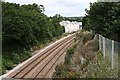
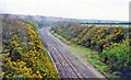
The Railway Line through Grampound Road
This photo was taken from the road bridge crossing the line. The very bright new houses are built where the railway station used to be.
Image: © Tony Atkin
Taken: 8 Jul 2006
0.17 miles
10
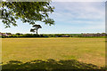
Grampound Road's Village Cricket Green
The community space in the middle of Grampound Road that takes in the Village Cricket Green as well as a children's play area.
Image: © Mike Lyne
Taken: 26 May 2020
0.17 miles