IMAGES TAKEN NEAR TO
Tresillian, TRURO, TR2 4BP
Introduction
This page details the photographs taken nearby to TR2 4BP by members of the Geograph project.
The Geograph project started in 2005 with the aim of publishing, organising and preserving representative images for every square kilometre of Great Britain, Ireland and the Isle of Man.

There are currently over 7.5m images from over14,400 individuals and you can help contribute to the project by visiting https://www.geograph.org.uk
Image Map
Images are licensed for reuse under creativecommons.org/licenses/by-sa/2.0
Notes
- Clicking on the map will re-center to the selected point.
- The higher the marker number, the further away the image location is from the centre of the postcode.
Image Listing (5 Images Found)
Images are licensed for reuse under creativecommons.org/licenses/by-sa/2.0
Image
Details
Distance
1
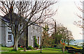
Polsue Manor Farm, Tresilian 1995
View southward, down to the Tresilian River. (A good B&B, where I stayed).
Image: © Ben Brooksbank
Taken: 23 Apr 1995
0.02 miles
2
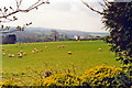
Down Tresilian Valley from Polsue Manor, 1995
View southward - peaceful Cornish scene.
Image: © Ben Brooksbank
Taken: 23 Apr 1995
0.02 miles
5

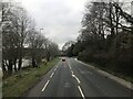
A390 approaching Tresillian
With detached houses on the left and the river behind the trees on the right.
Image: © Derek Harper
Taken: 18 Jul 2016
0.23 miles