IMAGES TAKEN NEAR TO
Tresillian, TRURO, TR2 4BD
Introduction
This page details the photographs taken nearby to TR2 4BD by members of the Geograph project.
The Geograph project started in 2005 with the aim of publishing, organising and preserving representative images for every square kilometre of Great Britain, Ireland and the Isle of Man.

There are currently over 7.5m images from over14,400 individuals and you can help contribute to the project by visiting https://www.geograph.org.uk
Image Map
Images are licensed for reuse under creativecommons.org/licenses/by-sa/2.0
Notes
- Clicking on the map will re-center to the selected point.
- The higher the marker number, the further away the image location is from the centre of the postcode.
Image Listing (29 Images Found)
Images are licensed for reuse under creativecommons.org/licenses/by-sa/2.0
Image
Details
Distance
2
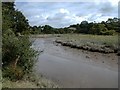
The Tresillian River, tributary of the Truro River Cornwall
Looking north-east (upstream), just behind the village of Tresillian towards the bridge. Upper reaches of the river, but still tidal, there are small flat-fish on the river bed. Opposite bank is Duchy of Cornwall land.
Image: © Situation
Taken: Unknown
0.04 miles
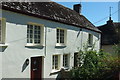
3
Wheel Inn, Tresillian
The listed inn on the A390 is described at https://www.historicengland.org.uk/listing/the-list/list-entry/1328881 : "C17 or earlier ... Said to have been used as Fairfax's headquarters during the Civil War (Battle of Tresillian)".
Image: © Derek Harper
Taken: 18 Jul 2016
0.07 miles
4
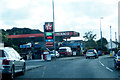
In Tresillian
Texaco service station in Tresillian.
Image: © Robert Ashby
Taken: 19 Aug 2014
0.07 miles
5
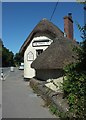
Cottage, Tresillian
On the right is the Wheel Inn https://www.historicengland.org.uk/listing/the-list/list-entry/1328881 .
Image: © Derek Harper
Taken: 18 Jul 2016
0.08 miles
6
Former toll house, Tresillian
Another view, across the A390, of the toll house shown in Image it is listed and described at https://www.historicengland.org.uk/listing/the-list/list-entry/1160970 .
Image: © Derek Harper
Taken: 18 Jul 2016
0.13 miles
7
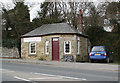
Tresillian Tollhouse by the A390, Main Road, Tresillian
Tollhouse by the A390, in the parish of St Clement (Carrick District), The Toll House, Main Road, Tresillian.
Grade II listed.
List Entry Number: 1160970 https://historicengland.org.uk/listing/the-list/list-entry/1160970
Surveyed
Milestone Society National ID: CW.STC01
Image: © Alan Rosevear
Taken: 26 Feb 2009
0.13 miles
9
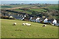
Pasture, St Clement
Sheep grazing above houses on Higher Polsue Way and Carharthen View in Tresillian. Probus is seen in the distance with the church tower and a silo at Trelowthas seen on the skyline.
Image: © Andrew Smith
Taken: 14 Jan 2022
0.16 miles
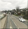
10
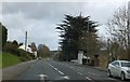
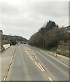
Bus stops on A390 in Tresillian
In the distance is the distinctive Tower House on the left.
Image: © David Smith
Taken: 1 Feb 2013
0.16 miles