IMAGES TAKEN NEAR TO
Tresillian, TRURO, TR2 4AU
Introduction
This page details the photographs taken nearby to TR2 4AU by members of the Geograph project.
The Geograph project started in 2005 with the aim of publishing, organising and preserving representative images for every square kilometre of Great Britain, Ireland and the Isle of Man.

There are currently over 7.5m images from over14,400 individuals and you can help contribute to the project by visiting https://www.geograph.org.uk
Image Map
Images are licensed for reuse under creativecommons.org/licenses/by-sa/2.0
Notes
- Clicking on the map will re-center to the selected point.
- The higher the marker number, the further away the image location is from the centre of the postcode.
Image Listing (26 Images Found)
Images are licensed for reuse under creativecommons.org/licenses/by-sa/2.0
Image
Details
Distance
2
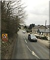
A390 at Tresillian Bridge
The lowest bridging point on the Tresillian River. In the background, the road taks a sharp turn left beside the church Image] and its hall.
Image: © Derek Harper
Taken: 18 Jul 2016
0.03 miles
5
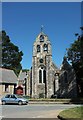
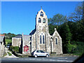
Holy Trinity church, Tresillian
Described at https://www.historicengland.org.uk/listing/the-list/list-entry/1141054 (which doesn't include the - maybe recent? - dedication), and seen across the junction of the A390 with the lane to Carharthen.
Image: © Derek Harper
Taken: 18 Jul 2016
0.03 miles
6
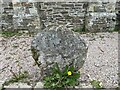
Old Wayside Cross at Tresillian
Tresillian Cross, a moved wayside cross with an old head. Set outside the west side of the church at Tresillian in St Michael Penkevil parish. Grade II Listed https://historicengland.org.uk/listing/the-list/list-entry/1328930. See also http://www.flickr.com/photos/ocifant/2952000960.
Milestone Society National ID: CWCA_SMP01
Image: © L Nott
Taken: 20 Apr 2021
0.03 miles
7
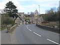
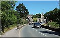
Tresillian bridge
Tresillian Church is the background is in the adjoining square SW8746.
Image: © Rod Allday
Taken: 4 Apr 2009
0.03 miles
8
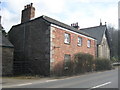
The Forge, Tresillian
Formerly a public house, now a private dwelling, unimaginatively called 'Brick House', although, to be fair, brick buildings are unusual in this area. Listed Grade II - more details here: http://www.imagesofengland.org.uk/Details/Default.aspx?id=62874&mode=adv
Image: © Rod Allday
Taken: 4 Apr 2009
0.04 miles
9
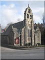
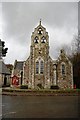
Tresillian Church
First built as a Chapel of Ease in 1878, rebuilt 1904. More details here: http://www.imagesofengland.org.uk/Details/Default.aspx?id=62872&mode=adv
Image: © Rod Allday
Taken: 4 Apr 2009
0.05 miles
10
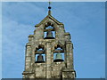
Church Bells at Tresillian
This unusual belfry tops the roof of the church.
Image: © Robin Lucas
Taken: 26 Mar 2004
0.05 miles