IMAGES TAKEN NEAR TO
Tresillian, TRURO, TR2 4AD
Introduction
This page details the photographs taken nearby to TR2 4AD by members of the Geograph project.
The Geograph project started in 2005 with the aim of publishing, organising and preserving representative images for every square kilometre of Great Britain, Ireland and the Isle of Man.

There are currently over 7.5m images from over14,400 individuals and you can help contribute to the project by visiting https://www.geograph.org.uk
Image Map
Images are licensed for reuse under creativecommons.org/licenses/by-sa/2.0
Notes
- Clicking on the map will re-center to the selected point.
- The higher the marker number, the further away the image location is from the centre of the postcode.
Image Listing (14 Images Found)
Images are licensed for reuse under creativecommons.org/licenses/by-sa/2.0
Image
Details
Distance
1
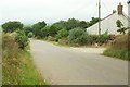
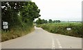
Road at Tregerrick
Passing the cottage at Tregerrick and approaching the junction at Tregerrick Cottage.
Image: © Derek Harper
Taken: 20 Jul 2016
0.02 miles
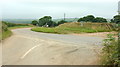
2
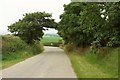
Junction near Tregerrick
With Cornish hedges on either side.
Image: © Derek Harper
Taken: 20 Jul 2016
0.05 miles
3
Junction near Tregerrick
Image: © Derek Harper
Taken: 20 Jul 2016
0.05 miles
4
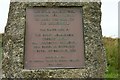
Plaque, Millennium stone, Tregerrick
Image: © Derek Harper
Taken: 20 Jul 2016
0.05 miles
5
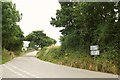
Junction near Tregerrick
Seen from afar in Image The road signs give hope to those heading for the advertised destinations, but in truth we are within a labyrinth of lanes that mean your itinerary will inevitably be indirect. In addition, as the reversing car on the left is finding out, there are plenty of places where passing is impossible.
Image: © Derek Harper
Taken: 20 Jul 2016
0.07 miles
6
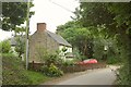
Cottage, Tregerrick
A few metres down the lane to Little Tregerrick.
Image: © Derek Harper
Taken: 20 Jul 2016
0.08 miles
7
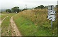
Near Tregerrick
A wide verge at the junction with the no through lane to Merther, crossed by a track. Over on the left is a millennium stone brought here from Boscawen-Ros, and shown in Image
Image: © Derek Harper
Taken: 20 Jul 2016
0.08 miles
8
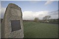
Millennium Stone near Tregerrick Farm
The inscription on the stone reads : "This stone brought from Boscawen Ros. St Buryan to mark the turn of the millennium was placed here by the Right Honourable George Hugh, 9th Viscount Falmouth, 26th Baron le Despenser & Baron of Boscawen Ros. Chairman of St Michael Penkivel Parish Council 1965-1999."
Image: © Philip White
Taken: 3 Dec 2006
0.13 miles
9
Junction near Tregerrick
Image: © Derek Harper
Taken: 20 Jul 2016
0.13 miles
10
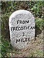
Old Milestone north of Tregerrick
Carved stone post by the UC road, in parish of ST MICHAEL PENKEVIL (CARRICK District), Tregerick, St Michael Penkevil Road, on the verge, back to bank. Tregothnan stone, erected by a private estate in the 19th century.
Inscription reads:-
FROM
TREGOTHNAN
3
MILES
Grade II Listed. List Entry Number: 1396482
https://historicengland.org.uk/listing/the-list/list-entry/1396482
Milestone Society National ID: CW_TT03.
Image: © Ian Thompson
Taken: 1 Jan 1998
0.13 miles