IMAGES TAKEN NEAR TO
Long Rock, PENZANCE, TR20 9TT
Introduction
This page details the photographs taken nearby to TR20 9TT by members of the Geograph project.
The Geograph project started in 2005 with the aim of publishing, organising and preserving representative images for every square kilometre of Great Britain, Ireland and the Isle of Man.

There are currently over 7.5m images from over14,400 individuals and you can help contribute to the project by visiting https://www.geograph.org.uk
Image Map (Loading...)


Getting Data...Please wait
Leaflet Map data © OpenStreetMap
Images are licensed for reuse under creativecommons.org/licenses/by-sa/2.0
Notes
- Clicking on the map will re-center to the selected point.
- The higher the marker number, the further away the image location is from the centre of the postcode.
Image Listing (60 Images Found)
Images are licensed for reuse under creativecommons.org/licenses/by-sa/2.0
Image
Details
Distance

2
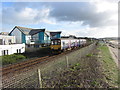
South West Coast Path and railway line near Long Rock
Image: © Gareth James
Taken: 21 Mar 2017
0.05 miles
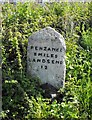
3
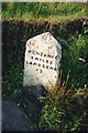
Old Milestone by the A394 in Longrock
Carved stone post by the A394, in parish of LUDGVAN (PENWITH District), Longrock, Y-junction; opposite Roundabout Garage, by the road, on South side of road. Hayle facets, erected by the Hayle Bridge Causeway turnpike trust in the 19th century.
Inscription reads:-
: PENZANCE / 2 MILES / LANDS END / 12 : : HAYLE / 6 MILES / CAMBORNE / 12 / REDRUTH / 15 / TRURO / 24 :
Grade II Listed. List Entry Number: 1327642
https://historicengland.org.uk/listing/the-list/list-entry/1327642
Milestone Society National ID: CW_PZCA02.
Image: © Ian Thompson
Taken: 10 Dec 2017
0.05 miles
4
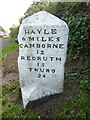
Old Milestone by the A394 in Longrock
Carved stone post by the A394, in parish of LUDGVAN (PENWITH District), Longrock, Y-junction; opposite Roundabout Garage, by the road, on South side of road. Hayle facets, erected by the Hayle Bridge Causeway turnpike trust in the 19th century.
Inscription reads:-
: PENZANCE / 2 MILES / LAND'S END / 22 : : HAYLE / 6 MILES / CAMBORNE / 12 / REDRUTH / 15 / TRURO / 24 :
Grade II listed.
List Entry Number: 1327642 https://historicengland.org.uk/listing/the-list/list-entry/1327642
Milestone Society National ID: CW_PZCA02.
Image: © Rosy Hanns
Taken: 27 Jun 2019
0.05 miles
8
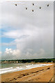
Marazion Beach and Sea King Helicopters
This was the last flight of 820 Squadron, Culdrose. Sea King Helicopters over Marazion Beach, Mounts Bay
Image: © Roy Hughes
Taken: 30 Jun 2003
0.07 miles
9
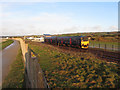
South West Coast Path near Marazion
The path parallels the railway line between the former Marazion station and Penzance.
Image: © Gareth James
Taken: 21 Mar 2017
0.08 miles
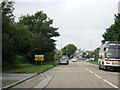
10
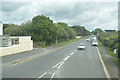
To Land's End
Milestone at Long Rock, on a stretch of road formerly part of the A30.
Image: © Malcolm Kewn
Taken: 19 Apr 2009
0.08 miles