IMAGES TAKEN NEAR TO
Penwerris Rise, PENZANCE, TR20 9TD
Introduction
This page details the photographs taken nearby to Penwerris Rise, TR20 9TD by members of the Geograph project.
The Geograph project started in 2005 with the aim of publishing, organising and preserving representative images for every square kilometre of Great Britain, Ireland and the Isle of Man.

There are currently over 7.5m images from over14,400 individuals and you can help contribute to the project by visiting https://www.geograph.org.uk
Image Map
Images are licensed for reuse under creativecommons.org/licenses/by-sa/2.0
Notes
- Clicking on the map will re-center to the selected point.
- The higher the marker number, the further away the image location is from the centre of the postcode.
Image Listing (41 Images Found)
Images are licensed for reuse under creativecommons.org/licenses/by-sa/2.0
Image
Details
Distance
3
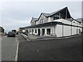
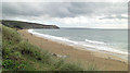
The entrance to Haulfryn Coast holiday park
Image: © David Medcalf
Taken: 17 Apr 2022
0.12 miles
5
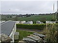
Looking down on Haulfryn Coast caravans
Image: © David Medcalf
Taken: 17 Apr 2022
0.13 miles
6
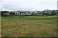
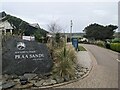
Praa Green
Grassy hinterland between the beach and the village. Much of it is used for car parking.
Image: © Bill Boaden
Taken: 7 Jul 2014
0.14 miles
7
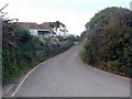
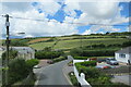
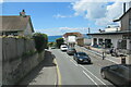
Pengersick Lane, Praa
Looking up the hill from the junction of Castle Drive
Image: © Rich Tea
Taken: 1 Aug 2006
0.15 miles
9
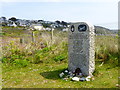
Sunderland flying boat memorial on Praa Green
The memorial commemorates the crew of RAF Coastal Command N/461 which, returning to base after an epic battle over the Bay of Biscay, on 2 June 1943 had to ditch in the sea at Praa Sands.
Image: © Rod Allday
Taken: 5 May 2016
0.17 miles
10
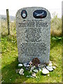
Detail of the Sunderland Flying Boat memorial on Praa Green
For context and more details see Image
Image: © Rod Allday
Taken: 5 May 2016
0.17 miles