IMAGES TAKEN NEAR TO
Dola Lane, PENZANCE, TR20 9PW
Introduction
This page details the photographs taken nearby to Dola Lane, TR20 9PW by members of the Geograph project.
The Geograph project started in 2005 with the aim of publishing, organising and preserving representative images for every square kilometre of Great Britain, Ireland and the Isle of Man.

There are currently over 7.5m images from over14,400 individuals and you can help contribute to the project by visiting https://www.geograph.org.uk
Image Map (Loading...)


Getting Data...Please wait
Leaflet Map data © OpenStreetMap
Images are licensed for reuse under creativecommons.org/licenses/by-sa/2.0
Notes
- Clicking on the map will re-center to the selected point.
- The higher the marker number, the further away the image location is from the centre of the postcode.
Image Listing (12 Images Found)
Images are licensed for reuse under creativecommons.org/licenses/by-sa/2.0
Image
Details
Distance


5
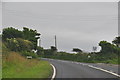
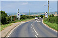
Cornwall : The A394
The A394 heading through Cornwall.
Image: © Lewis Clarke
Taken: 16 Jul 2015
0.09 miles
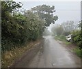
6
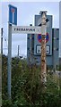
Old Direction Sign - Signpost by the A394, Perranuthnoe
Pyramid finial - 1 arm; by the A394, in parish of Perranuthnoe (Penwith District), Trebarvah turn, against a hedge.
To be surveyed
Milestone Society National ID: CW_SW5429
Image: © Milestone Society
Taken: Unknown
0.09 miles
8
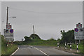
Cornwall : The A394
Heading into the village of Rosudgeon along the A394.
Image: © Lewis Clarke
Taken: 16 Jul 2015
0.11 miles
10
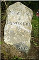
Old Milestone by the A394, opposite Trevelyan Farm
Carved stone post by the A394, in parish of PERRANUTHNOE (PENWITH District), Trevelyan Farm, on footpath beside road, on South side of road. Helston facets, erected by the Helston turnpike trust in the 19th century.
Inscription reads:-
: PENZANCE / 5 / LANDS END / 15 : : HELSTON / 8 / FALMOUTH / 20 :
Carved benchmark on base.
Grade II listed.
List Entry Number: 1143770 https://historicengland.org.uk/listing/the-list/list-entry/1143770
Milestone Society National ID: CW_PZHL05.
Image: © Rosy Hanns
Taken: 26 Jul 2019
0.22 miles