IMAGES TAKEN NEAR TO
Colenso Cross, PENZANCE, TR20 9HU
Introduction
This page details the photographs taken nearby to Colenso Cross, TR20 9HU by members of the Geograph project.
The Geograph project started in 2005 with the aim of publishing, organising and preserving representative images for every square kilometre of Great Britain, Ireland and the Isle of Man.

There are currently over 7.5m images from over14,400 individuals and you can help contribute to the project by visiting https://www.geograph.org.uk
Image Map
Images are licensed for reuse under creativecommons.org/licenses/by-sa/2.0
Notes
- Clicking on the map will re-center to the selected point.
- The higher the marker number, the further away the image location is from the centre of the postcode.
Image Listing (4 Images Found)
Images are licensed for reuse under creativecommons.org/licenses/by-sa/2.0
Image
Details
Distance
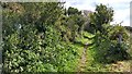
3
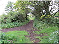
Track from New Road to Higher Downs
Looking westward.
Image: © Peter Wood
Taken: 30 Apr 2017
0.16 miles
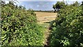
4
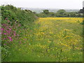
Buttercup Meadow, Packet Lane
Packet Lane runs north from the Falmouth Packet pub. Looking towards Godolphin.
Image: © Sheila Russell
Taken: 24 May 2006
0.21 miles