IMAGES TAKEN NEAR TO
Trewhella Lane, PENZANCE, TR20 9ED
Introduction
This page details the photographs taken nearby to Trewhella Lane, TR20 9ED by members of the Geograph project.
The Geograph project started in 2005 with the aim of publishing, organising and preserving representative images for every square kilometre of Great Britain, Ireland and the Isle of Man.

There are currently over 7.5m images from over14,400 individuals and you can help contribute to the project by visiting https://www.geograph.org.uk
Image Map (Loading...)


Getting Data...Please wait
Leaflet Map data © OpenStreetMap
Images are licensed for reuse under creativecommons.org/licenses/by-sa/2.0
Notes
- Clicking on the map will re-center to the selected point.
- The higher the marker number, the further away the image location is from the centre of the postcode.
Image Listing (5 Images Found)
Images are licensed for reuse under creativecommons.org/licenses/by-sa/2.0
Image
Details
Distance
3
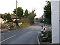
Roadside Houses on Relubbus Lane
The landscape around Higher Downs and Lower Downs is littered with hamlet sized settlements such as this, remnants of the days when this was a mining district.
Image: © Tony Atkin
Taken: 14 Jan 2006
0.14 miles
4
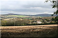
Field at Higher Downs
The building is the former chapel at Halamanning and in the distance on the right is Godolphin Hill.
Image: © Rod Allday
Taken: 21 Oct 2011
0.22 miles
5
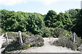
Mine shaft
The protection around this mine shaft has fallen into disrepair.
Image: © Elizabeth Scott
Taken: 2 Jul 2011
0.25 miles