
IMAGES TAKEN NEAR TO
St. Hilary, PENZANCE, TR20 9DQ
Introduction
This page details the photographs taken nearby to TR20 9DQ by members of the Geograph project.
The Geograph project started in 2005 with the aim of publishing, organising and preserving representative images for every square kilometre of Great Britain, Ireland and the Isle of Man.

There are currently over 7.5m images from over14,400 individuals and you can help contribute to the project by visiting https://www.geograph.org.uk
Image Map
Images are licensed for reuse under creativecommons.org/licenses/by-sa/2.0
Notes
- Clicking on the map will re-center to the selected point.
- The higher the marker number, the further away the image location is from the centre of the postcode.
Image Listing (53 Images Found)
Images are licensed for reuse under creativecommons.org/licenses/by-sa/2.0
Image
Details
Distance
1
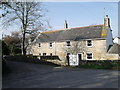
Row of cottages by church, St. Hilary's, Cornwall
Image: © nick macneill
Taken: 9 Apr 2011
0.03 miles
2

St Hilary - Inscribed stone
This stone near to the southern gateway in the churchyard of St Hilary has an inscription written vertically. Carved from Granite it days to c.C4th AD
It is EH Grade II listed: https://historicengland.org.uk/listing/the-list/list-entry/1143751?section=official-list-entry
Image: © Rob Farrow
Taken: 19 Jul 2025
0.03 miles
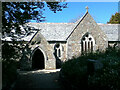
4
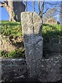
Old Wayside Cross moved to St Hilary church
St Hilary Cross, the old head and shaft of a wayside cross moved to the left-hand side of the churchyard path leading to the south porch of St Hilary church in St Hilary parish. Grade II Listed https://historicengland.org.uk/listing/the-list/list-entry/1161186.
Milestone Society National ID: CWPW_SHI08
Image: © L Nott
Taken: 12 Jan 2022
0.04 miles
5
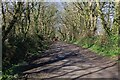
Tree-lined bridleway
Looking along the tree-lined bridleway approaching St. Hilary.
Image: © Elizabeth Scott
Taken: 14 Mar 2023
0.04 miles
6
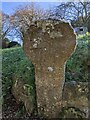
Old Wayside Cross moved to St Hilary church
Trevabyn Cross, the old head and shaft of a wayside cross moved to the right-hand side of the churchyard path leading to the south porch of St Hilary church in St Hilary parish. Grade II Listed https://historicengland.org.uk/listing/the-list/list-entry/1161059. See also http://www.flickr.com/photos/ocifant/2836499215 and http://www.flickr.com/photos/ocifant/2951919458.
Milestone Society National ID: CWPW_SHI01
Image: © L Nott
Taken: 12 Jan 2022
0.04 miles
9
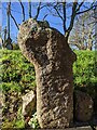
Old Wayside Cross moved to St Hilary church
Trewhella Cross, the old head and shaft of a wayside cross moved to the left-hand side of the churchyard path leading to the south porch of St Hilary church in St Hilary parish. Grade II Listed https://historicengland.org.uk/listing/the-list/list-entry/1161079. See also http://www.flickr.com/photos/ocifant/2951917002 and https://www.flickr.com/photos/ocifant/2837332196.
Milestone Society National ID: CWPW_SHI02
Image: © L Nott
Taken: 12 Jan 2022
0.04 miles
10

St Hilary - Rood
The figure of Christ on the cross is known as a "rood" - and in mediæval churches it was usually positioned above a (usually wooden) fretwork screen - known as the "Rood Screen". Very few mediæval roods survive due to the iconoclasm of the Reformation, but a good number of the screens still do. Here however we have a modern rood with no accompanying screen. Since the Reformation, crucifixes had been forbidden in churches, but by the C19th, with the renewed interest in Gothic and Mediaeval architecture they had become more acceptable - but still highly unpopular with strict Protestants who considered them "Popish".
This crucifix is by Ernest Proctor the most prolific contributor to the Newlyn School artworks in the church.
Image: © Rob Farrow
Taken: 19 Jul 2025
0.04 miles