IMAGES TAKEN NEAR TO
Long Rock, PENZANCE, TR20 8YJ
Introduction
This page details the photographs taken nearby to TR20 8YJ by members of the Geograph project.
The Geograph project started in 2005 with the aim of publishing, organising and preserving representative images for every square kilometre of Great Britain, Ireland and the Isle of Man.

There are currently over 7.5m images from over14,400 individuals and you can help contribute to the project by visiting https://www.geograph.org.uk
Image Map
Images are licensed for reuse under creativecommons.org/licenses/by-sa/2.0
Notes
- Clicking on the map will re-center to the selected point.
- The higher the marker number, the further away the image location is from the centre of the postcode.
Image Listing (9 Images Found)
Images are licensed for reuse under creativecommons.org/licenses/by-sa/2.0
Image
Details
Distance
1
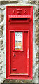
Victorian postbox on Long Lane
Postbox No. TR20 142.
See Image] for context.
Image: © JThomas
Taken: 13 Jul 2017
0.07 miles
2
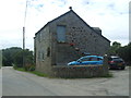
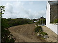
Cottage on Long Lane
Showing position of Victorian Postbox No. TR20 142.
See Image] for postbox.
Image: © JThomas
Taken: 13 Jul 2017
0.07 miles
3
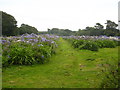
Field of Agapanthus near Varfell
Probably a crop grown by Winchester Growers who cultivate many of the fields around here, growing various types of flowers for the retail market.
Image: © Rod Allday
Taken: 4 Sep 2010
0.10 miles

6
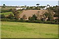
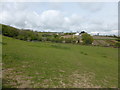
Eglos Farm
Looking over a valley to the houses at Eglos Farm. The church spire of Ludgvan village can be seen on the horizon.
Image: © Tony Atkin
Taken: 28 Aug 2007
0.15 miles