IMAGES TAKEN NEAR TO
Newmill, PENZANCE, TR20 8UU
Introduction
This page details the photographs taken nearby to TR20 8UU by members of the Geograph project.
The Geograph project started in 2005 with the aim of publishing, organising and preserving representative images for every square kilometre of Great Britain, Ireland and the Isle of Man.

There are currently over 7.5m images from over14,400 individuals and you can help contribute to the project by visiting https://www.geograph.org.uk
Image Map (Loading...)


Getting Data...Please wait
Leaflet Map data © OpenStreetMap
Images are licensed for reuse under creativecommons.org/licenses/by-sa/2.0
Notes
- Clicking on the map will re-center to the selected point.
- The higher the marker number, the further away the image location is from the centre of the postcode.
Image Listing (12 Images Found)
Images are licensed for reuse under creativecommons.org/licenses/by-sa/2.0
Image
Details
Distance
1
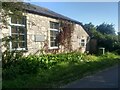
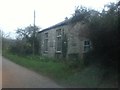
The Teetotal Chapel at Newmill
The chapel seems to have been converted to a private house. I wonder if it is still teetotal?
Image: © David Medcalf
Taken: 17 Sep 2020
0.02 miles
2
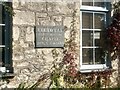
The sign on the chapel wall
It's nice that the sign is retained, though the building has been converted to a house.
Image: © David Medcalf
Taken: 17 Sep 2020
0.03 miles
4
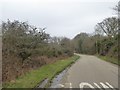
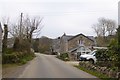
Slow down on this narrow road
The road marking "Slow" seems redundant; the road is narrow and winds through woodleand, but there is a junction ahead
Image: © David Smith
Taken: 14 Mar 2016
0.07 miles
5
Newmill Wesleyan teetotal chapel
Built 1841
Image: © Paul Barnett
Taken: 1 Dec 2015
0.10 miles
8
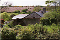
Madron: New Mill
The mill now forms part of a private residence but retains a kiln once used for drying oats. There were formerly two overshot waterwheels here; the second wheel went to Zennor Museum, apparently
Image: © Martin Bodman
Taken: Unknown
0.20 miles
9
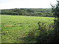
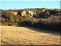
Farmland near Bay of Biscay
"Bay of Biscay" is the quaintly named house just visible in the trees.
Image: © David Medcalf
Taken: 11 Sep 2007
0.20 miles
10

Direction Sign ? Signpost
Located on the east side of the T junction in New Mill in Madron parish. 3 arms and ball finial. See also https://www.flickr.com/photos/38116967@N04/8108943690.
Milestone Society National ID: CW_SW4534C
Image: © J Blemings
Taken: 2 Oct 2019
0.23 miles