IMAGES TAKEN NEAR TO
Stable Hobba, PENZANCE, TR20 8TL
Introduction
This page details the photographs taken nearby to Stable Hobba, TR20 8TL by members of the Geograph project.
The Geograph project started in 2005 with the aim of publishing, organising and preserving representative images for every square kilometre of Great Britain, Ireland and the Isle of Man.

There are currently over 7.5m images from over14,400 individuals and you can help contribute to the project by visiting https://www.geograph.org.uk
Image Map
Images are licensed for reuse under creativecommons.org/licenses/by-sa/2.0
Notes
- Clicking on the map will re-center to the selected point.
- The higher the marker number, the further away the image location is from the centre of the postcode.
Image Listing (17 Images Found)
Images are licensed for reuse under creativecommons.org/licenses/by-sa/2.0
Image
Details
Distance
1
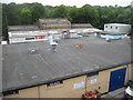
The roofs of Stable Hobba Industrial Estate
Image: © David Medcalf
Taken: 10 Jun 2012
0.02 miles
2
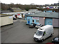
Stable Hobba Industrial Estate, Newlyn
Plenty of fish for sale
Image: © Sheila Russell
Taken: 5 Jan 2006
0.04 miles
3
Valley of Newlyn Coombe River
The road into Newlyn crosses the river on a small bridge here. The river has flowed from the Drift Reservoir, a short way inland.
Image: © David Smith
Taken: 18 Jan 2014
0.06 miles
4

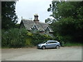
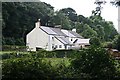
Smallholding with chicken and ducks
On the piece of land bordered by the stream, the Newlyn Coombe road and the footpath there is a smallholding where chicken and ducks are kept.
Image: © Elizabeth Scott
Taken: 21 Sep 2012
0.08 miles
5
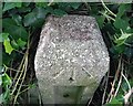
Ordnance Survey Rivet
This OS rivet can be found on the concrete post north side of The Coombe. It marks a point 26.781m above mean sea level.
Image: © Adrian Dust
Taken: 5 Jun 2024
0.09 miles
7

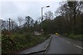
Penzance : Newlyn - The Coombe B3315
Looking along the road.
Image: © Lewis Clarke
Taken: 28 Sep 2022
0.11 miles

9
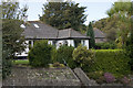
Bungalows in Lower Gurnick Road
Bungalows in Lower Gurnick Road, near to the bottom of the hill where the road curves.
Image: © Elizabeth Scott
Taken: 21 Sep 2012
0.14 miles