IMAGES TAKEN NEAR TO
Sancreed, PENZANCE, TR20 8QW
Introduction
This page details the photographs taken nearby to TR20 8QW by members of the Geograph project.
The Geograph project started in 2005 with the aim of publishing, organising and preserving representative images for every square kilometre of Great Britain, Ireland and the Isle of Man.

There are currently over 7.5m images from over14,400 individuals and you can help contribute to the project by visiting https://www.geograph.org.uk
Image Map
Images are licensed for reuse under creativecommons.org/licenses/by-sa/2.0
Notes
- Clicking on the map will re-center to the selected point.
- The higher the marker number, the further away the image location is from the centre of the postcode.
Image Listing (7 Images Found)
Images are licensed for reuse under creativecommons.org/licenses/by-sa/2.0
Image
Details
Distance
1
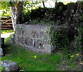
Out of milk
Another long-disused milk churn stand in west Penwith.
Image: © Malcolm Kewn
Taken: 21 May 2010
0.12 miles
2
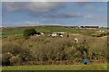
View to Ennestreven Farm
A view to Ennestreven Farm from the road beneath Sancreed Beacon.
Image: © Elizabeth Scott
Taken: 23 Feb 2023
0.13 miles
3
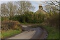
Bend in the road
The road bends at 90 degrees here.
Image: © Elizabeth Scott
Taken: 23 Feb 2023
0.15 miles
4
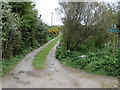
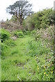
Track and Footpath to Rhoscreel
Looking southward.
Image: © Peter Wood
Taken: 1 May 2017
0.15 miles
5
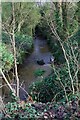
Stream flows beneath road 2
Presumably this stream would have powered Trannack Mill.
Image: © Elizabeth Scott
Taken: 23 Feb 2023
0.20 miles
6
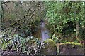
Stream flows beneath road 1
Standing in the road, I included the stones of the bridge parapet in this shot.
Image: © Elizabeth Scott
Taken: 23 Feb 2023
0.23 miles