IMAGES TAKEN NEAR TO
Lower Bostraze, Newbridge, PENZANCE, TR20 8PU
Introduction
This page details the photographs taken nearby to TR20 8PU by members of the Geograph project.
The Geograph project started in 2005 with the aim of publishing, organising and preserving representative images for every square kilometre of Great Britain, Ireland and the Isle of Man.

There are currently over 7.5m images from over14,400 individuals and you can help contribute to the project by visiting https://www.geograph.org.uk
Image Map (Loading...)


Getting Data...Please wait
Leaflet Map data © OpenStreetMap
Images are licensed for reuse under creativecommons.org/licenses/by-sa/2.0
Notes
- Clicking on the map will re-center to the selected point.
- The higher the marker number, the further away the image location is from the centre of the postcode.
Image Listing (4 Images Found)
Images are licensed for reuse under creativecommons.org/licenses/by-sa/2.0
Image
Details
Distance
1
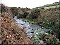
Stream at Lower Bostraze
Two streams join in the Tregeseal Valley, below this point. They then flow through Nancherrow and out to the sea at Porth Ledden, through the Kenidjack valley Image In the 19th century the water from these streams powered the machinery for the mining lower down the valley. Plenty of water today, after several weeks of rain saturating the peaty commonland above. This photograph was taken just to the west of the old China Clay works at Lower Bostraze.
Image: © Sheila Russell
Taken: 8 Dec 2005
0.14 miles
2
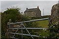
Hailglower Farm 1
Image: © Elizabeth Scott
Taken: 2 Jul 2023
0.19 miles
3
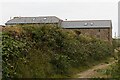
Hailglower Farm 2
Image: © Elizabeth Scott
Taken: 2 Jul 2023
0.21 miles
4
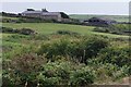
Hailglower Farm 3
Hailglower Farm viewed from the pond. The name Hailglower is from Cornish "helik-lowarth", willow garden. See also Image and Image
Image: © Elizabeth Scott
Taken: 2 Jul 2023
0.21 miles