IMAGES TAKEN NEAR TO
Bosullow, PENZANCE, TR20 8NT
Introduction
This page details the photographs taken nearby to TR20 8NT by members of the Geograph project.
The Geograph project started in 2005 with the aim of publishing, organising and preserving representative images for every square kilometre of Great Britain, Ireland and the Isle of Man.

There are currently over 7.5m images from over14,400 individuals and you can help contribute to the project by visiting https://www.geograph.org.uk
Image Map
Images are licensed for reuse under creativecommons.org/licenses/by-sa/2.0
Notes
- Clicking on the map will re-center to the selected point.
- The higher the marker number, the further away the image location is from the centre of the postcode.
Image Listing (23 Images Found)
Images are licensed for reuse under creativecommons.org/licenses/by-sa/2.0
Image
Details
Distance
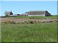
2
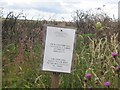
A very pertinent warning from The National Trust!
This picture was taken on the track leading up to Garden Mine Cottage
Image: © M Hunter
Taken: 27 Jul 2006
0.15 miles
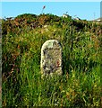
3
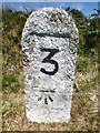
Old Milestone on Bosullow Common
Carved stone post by the UC road, in parish of MADRON (PENWITH District), Bosullow Common, on open moor, 110m NE of Bosullow, 3m from road on far side of ditch, on North side of road. Raised number, erected by the parish in the 18th century.
Inscription reads:-
3
Carved benchmark below front recess.
Grade II listed.
List Entry Number: 1406892 https://historicengland.org.uk/listing/the-list/list-entry/1406892
Milestone Society National ID: CW_MDMV03.
Image: © Rosy Hanns
Taken: 4 Jul 2019
0.16 miles
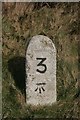
4
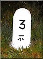
Old Milestone on Bosullow Common
Carved stone post by the UC road, in parish of MADRON (PENWITH District), Bosullow Common, on open moor, 110m North East of Bosullow, 3m from road on far side of ditch, on North side of road. Raised number stone, erected by the parish in the 18th century.
Inscription once read:-
: (MADRON / 3 / MORVAH / 1) :
Carved benchmark below front recess.
Grade II Listed. List Entry Number: 1406892
https://historicengland.org.uk/listing/the-list/list-entry/1406892
Milestone Society National ID: CW_MDMV03.
Image: © Ian Thompson
Taken: 11 Mar 2009
0.16 miles
5
Faceless
Defaced milestone on Bosullow Common.
Image: © Malcolm Kewn
Taken: 15 Jun 2010
0.16 miles
6
Milestone on minor road north of Penzance
Although it doesn't say so, I think the three miles must refer to the distance to Penzance. The Ordnance Survey benchmark on the stone is described on the database at http://www.bench-marks.org.uk/bm73493.
Image: © Becky Williamson
Taken: 8 Feb 2016
0.16 miles
7
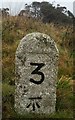
Milestone - Madron 3
The OS cut mark on the front marks a point 181.42m above mean sea level.
Image: © Adrian Dust
Taken: 21 Feb 2017
0.16 miles
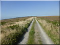
9
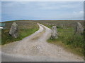
Track across the moor leading to Garden Mine Cottage
Image: © Rod Allday
Taken: 14 Jun 2008
0.18 miles
10
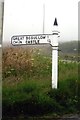
Direction Sign - Signpost on Bosullow Common
Spear finial - 1 arm; by the UC road, in parish of Madron (Penwith District), East of Bosullow, on grass verge.
To be surveyed
Milestone Society National ID: CW_SW4134
Image: © A Langdon
Taken: 23 Jul 2011
0.19 miles