IMAGES TAKEN NEAR TO
Nancledra, PENZANCE, TR20 8LR
Introduction
This page details the photographs taken nearby to TR20 8LR by members of the Geograph project.
The Geograph project started in 2005 with the aim of publishing, organising and preserving representative images for every square kilometre of Great Britain, Ireland and the Isle of Man.

There are currently over 7.5m images from over14,400 individuals and you can help contribute to the project by visiting https://www.geograph.org.uk
Image Map (Loading...)


Getting Data...Please wait
Leaflet Map data © OpenStreetMap
Images are licensed for reuse under creativecommons.org/licenses/by-sa/2.0
Notes
- Clicking on the map will re-center to the selected point.
- The higher the marker number, the further away the image location is from the centre of the postcode.
Image Listing (19 Images Found)
Images are licensed for reuse under creativecommons.org/licenses/by-sa/2.0
Image
Details
Distance
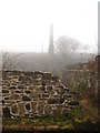
2
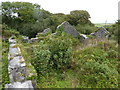
Derelict buildings at the Clay dry
On the eastern side, looking north.
Image: © David Medcalf
Taken: 30 Aug 2013
0.07 miles
3
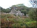
Remains of china clay works at Baker's Pit
For details see Image
Image: © Rod Allday
Taken: 6 Oct 2010
0.08 miles
5
The pan kiln at Baker's Pit clay dry
Looking along the length of the kiln towards the flue. The furnace doors are just below the bottom of the photo Image The clay was laid out on the floor of the dry and the heat travelled under the floor from the furnace to the flue, drying the clay in the process.
Image: © Rod Allday
Taken: 1 Apr 2011
0.08 miles
6
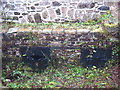
Furnace doors at Baker's Pit clay dry
The Cornwall Wildlife Trust, which now owns the area, has recently carried out much work to clear vegetation and this has revealed these cast iron doors, which are in remarkably good condition. For context see Image
Image: © Rod Allday
Taken: 1 Apr 2011
0.08 miles
7
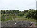
Disused mine buildings at Tredorwin
This is probably a complex of disused mine buildings. But I cannot find any information about them.
Image: © Graham Horn
Taken: 6 Jul 2011
0.09 miles
8
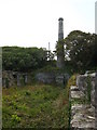
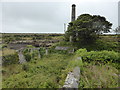
Chimney stack at Baker's Pit
This is the chimney of the pan kiln, where the better quality clay was dried.
Baker's Pit is the amalgamation of several of the early clay pits of the Towednack area, including Bedlam Green, Bohemia, Little Bohemia, Georgia, Little Georgia and Polhigey. These works date back to the early 19th century. In 1868 or 1869 the works were acquired by William King Baker and Company. Baker died in 1910 and the works were taken over by the Loverings, subsequently Lovering and Pochin Ltd., only to stop for the Great War. The pit reopened shortly after the end of the war but did not get back to full production, despite an attempt to install electrical equipment. Baker's Pit passed into the hands of the newly formed English China Clays in 1932 and officially closed in 1942.
Image: © Rod Allday
Taken: 6 Oct 2010
0.10 miles
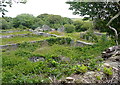
9
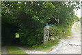
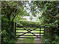
Entrance to Pigmoor Cottage
To the left, Pigmoor Cottage. To the right, a track that is a footpath on the open access land of Trenowin Downs.
Image: © Graham Horn
Taken: 6 Jul 2011
0.10 miles
10
Another view of the Clay dry chimney
Taken from on top of the old central wall.
Image: © David Medcalf
Taken: 30 Aug 2013
0.10 miles