IMAGES TAKEN NEAR TO
Crowlas, PENZANCE, TR20 8AB
Introduction
This page details the photographs taken nearby to TR20 8AB by members of the Geograph project.
The Geograph project started in 2005 with the aim of publishing, organising and preserving representative images for every square kilometre of Great Britain, Ireland and the Isle of Man.

There are currently over 7.5m images from over14,400 individuals and you can help contribute to the project by visiting https://www.geograph.org.uk
Image Map
Images are licensed for reuse under creativecommons.org/licenses/by-sa/2.0
Notes
- Clicking on the map will re-center to the selected point.
- The higher the marker number, the further away the image location is from the centre of the postcode.
Image Listing (38 Images Found)
Images are licensed for reuse under creativecommons.org/licenses/by-sa/2.0
Image
Details
Distance
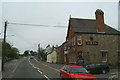
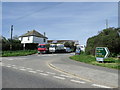
1
Entering Crowlas
Looking north east on the A30.
Image: © JThomas
Taken: 13 Jul 2017
0.02 miles
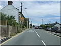
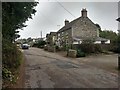
2
The B3309 turning to Ludgvan
Off the A30 at Crowlas
Image: © David Long
Taken: 10 May 2006
0.04 miles
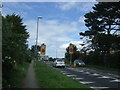
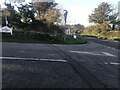
3
Junction between the A30 and B3309, Crowlas
Image: © nick macneill
Taken: 6 Apr 2011
0.04 miles
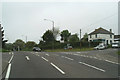
8

Crowlas : A30
Looking along the A30 heading through Crowlas.
Image: © Lewis Clarke
Taken: 28 Sep 2022
0.08 miles