IMAGES TAKEN NEAR TO
TRURO, TR1 9JR
Introduction
This page details the photographs taken nearby to TR1 9JR by members of the Geograph project.
The Geograph project started in 2005 with the aim of publishing, organising and preserving representative images for every square kilometre of Great Britain, Ireland and the Isle of Man.

There are currently over 7.5m images from over14,400 individuals and you can help contribute to the project by visiting https://www.geograph.org.uk
Image Map
Images are licensed for reuse under creativecommons.org/licenses/by-sa/2.0
Notes
- Clicking on the map will re-center to the selected point.
- The higher the marker number, the further away the image location is from the centre of the postcode.
Image Listing (27 Images Found)
Images are licensed for reuse under creativecommons.org/licenses/by-sa/2.0
Image
Details
Distance
1
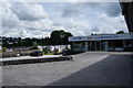
Cornwall Bathroom Centre
Occupying an out-of-town site on Newham Industrial Estate.
Image: © Bill Boaden
Taken: 28 Jun 2014
0.04 miles
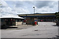
3
Edhen Park, Truro
Former industrial premises now in multiple occupation as units.
Image: © Bill Boaden
Taken: 28 Jun 2014
0.05 miles
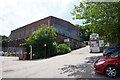
4
Boat for sale
I am not convinced that it could be very easily floated out of this passage down to the estuary.
Image: © Bill Boaden
Taken: 28 Jun 2014
0.05 miles
5
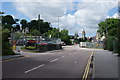
Newham Road, Truro
The road passes various commercial enterprises on Newham Industrial Estate, such as Cornwall Woodburners on the left. Truro Cathedral stands in the background.
Image: © Bill Boaden
Taken: 28 Jun 2014
0.06 miles
6
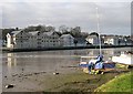
Apartments on The Truro River
Modern offices and apartment blocks built on the wharves on the western side of the tidal Truro River.
Image: © Tony Atkin
Taken: 2 Jan 2006
0.12 miles
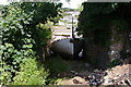
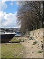
7
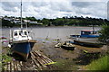
Beached boats in the Malpas Estuary
The Truro River is tidal here, and the tide is coming in.
Image: © Bill Boaden
Taken: 28 Jun 2014
0.12 miles
8

End of The Line
This car park marks the end of the Image
Image: © Glyn Baker
Taken: 4 Oct 2015
0.14 miles
9
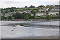
Truro River at low tide
The twisting course of the channel up the Truro river is marked by the port (red) and starboard (green) hand markers. The mudbanks are constantly shifting, however, so a mark can quickly become out of position and outside the channel there is very little depth of water even at high tide. Trying to reach the head of the river other than at the very top of the tide is hazardous.
Image: © Graham Loveland
Taken: 27 Aug 2010
0.15 miles
10
On the bank of the Truro River at low tide
Image: © Rod Allday
Taken: 14 Apr 2008
0.15 miles