IMAGES TAKEN NEAR TO
Lower Boscaswell, Pendeen, PENZANCE, TR19 7UF
Introduction
This page details the photographs taken nearby to TR19 7UF by members of the Geograph project.
The Geograph project started in 2005 with the aim of publishing, organising and preserving representative images for every square kilometre of Great Britain, Ireland and the Isle of Man.

There are currently over 7.5m images from over14,400 individuals and you can help contribute to the project by visiting https://www.geograph.org.uk
Image Map (Loading...)


Getting Data...Please wait
Leaflet Map data © OpenStreetMap
Images are licensed for reuse under creativecommons.org/licenses/by-sa/2.0
Notes
- Clicking on the map will re-center to the selected point.
- The higher the marker number, the further away the image location is from the centre of the postcode.
Image Listing (4 Images Found)
Images are licensed for reuse under creativecommons.org/licenses/by-sa/2.0
Image
Details
Distance
1
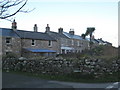
Miners' cottages at Lower Boscaswell
Lower Boscaswell just outside Pendeen is a settlement originally consisting predominantly of housing for miners employed in the various mines in the area. In addition to several terraces of stone cottages like this one there is a lot of late-C20th social housing - an unusual occurrence in such a rural area.
Image: © Rod Allday
Taken: 3 Jan 2009
0.06 miles
2
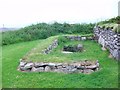
Restored Holy Well at Lower Boscaswell
Well maintained restored Holy Well.
Image: © Michael Murray
Taken: 10 Jun 2010
0.20 miles
3
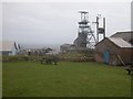
Geevor tin mine
Taken during a visit 10 years ago.
Image: © Stephen Darlington
Taken: 28 Apr 2005
0.21 miles
4
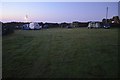
Nine PM at Pendeen campsite
The campsite is £5 pppn (2012) easy walk to Levant, Geevor, Pendeen watch etc. In Pub grounds.
Image: © Ashley Dace
Taken: 7 Sep 2012
0.24 miles