IMAGES TAKEN NEAR TO
Parc An Yorth, PENZANCE, TR19 7UD
Introduction
This page details the photographs taken nearby to Parc An Yorth, TR19 7UD by members of the Geograph project.
The Geograph project started in 2005 with the aim of publishing, organising and preserving representative images for every square kilometre of Great Britain, Ireland and the Isle of Man.

There are currently over 7.5m images from over14,400 individuals and you can help contribute to the project by visiting https://www.geograph.org.uk
Image Map
Images are licensed for reuse under creativecommons.org/licenses/by-sa/2.0
Notes
- Clicking on the map will re-center to the selected point.
- The higher the marker number, the further away the image location is from the centre of the postcode.
Image Listing (32 Images Found)
Images are licensed for reuse under creativecommons.org/licenses/by-sa/2.0
Image
Details
Distance
3
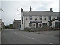
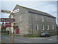
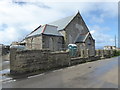
Houses and Methodist Chapel, Trewellard, Cornwall
Image: © nick macneill
Taken: 6 Apr 2011
0.06 miles
5
The Methodist Chapel at Trewellard
Removal of picture.
Image: © Row17
Taken: 29 Jul 2008
0.07 miles
6
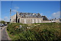
Former Wesleyan Sunday School
Missing a roof, and you wouldn't think it would survive long in this state.
Image: © Bill Boaden
Taken: 11 Jul 2014
0.08 miles
8
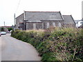
Trewellard Wesleyan Sunday School
Dated 1908, now in a sorry state.
Image: © Rod Allday
Taken: 18 Sep 2009
0.08 miles
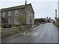
9
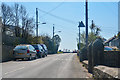
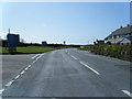
Trewellard : The B3306
The B3306 heads through Trewellard.
Image: © Lewis Clarke
Taken: 21 Apr 2018
0.08 miles
10
Wesleyan Sunday School, Trewellard
Dated 1908 and being renovated at the time of this photograph.
Image: © Maurice D Budden
Taken: 18 May 2016
0.08 miles