IMAGES TAKEN NEAR TO
Pendeen, PENZANCE, TR19 7TS
Introduction
This page details the photographs taken nearby to TR19 7TS by members of the Geograph project.
The Geograph project started in 2005 with the aim of publishing, organising and preserving representative images for every square kilometre of Great Britain, Ireland and the Isle of Man.

There are currently over 7.5m images from over14,400 individuals and you can help contribute to the project by visiting https://www.geograph.org.uk
Image Map (Loading...)


Getting Data...Please wait
Leaflet Map data © OpenStreetMap
Images are licensed for reuse under creativecommons.org/licenses/by-sa/2.0
Notes
- Clicking on the map will re-center to the selected point.
- The higher the marker number, the further away the image location is from the centre of the postcode.
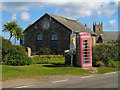
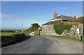
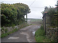
Image Listing (10 Images Found)
Images are licensed for reuse under creativecommons.org/licenses/by-sa/2.0
Image
Details
Distance
2
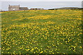
Buttercup meadow at Morvah
The public footpath leads through this lovely field of buttercups.
Image: © Elizabeth Scott
Taken: 31 May 2010
0.12 miles
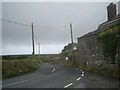
3
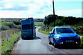
The B3306
Passing traffic near Rose Valley.
Image: © Robert Ashby
Taken: 20 Aug 2014
0.14 miles
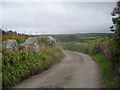
10
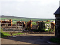
Milking time at Keigwin
Looking east. Dry Carn in the background.
Image: © Sheila Russell
Taken: 30 Oct 2005
0.25 miles