IMAGES TAKEN NEAR TO
Higher Bosavern, St. Just, PENZANCE, TR19 7QZ
Introduction
This page details the photographs taken nearby to TR19 7QZ by members of the Geograph project.
The Geograph project started in 2005 with the aim of publishing, organising and preserving representative images for every square kilometre of Great Britain, Ireland and the Isle of Man.

There are currently over 7.5m images from over14,400 individuals and you can help contribute to the project by visiting https://www.geograph.org.uk
Image Map
Images are licensed for reuse under creativecommons.org/licenses/by-sa/2.0
Notes
- Clicking on the map will re-center to the selected point.
- The higher the marker number, the further away the image location is from the centre of the postcode.
Image Listing (31 Images Found)
Images are licensed for reuse under creativecommons.org/licenses/by-sa/2.0
Image
Details
Distance
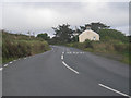
2
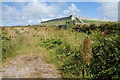
Carn Bosavern
A view looking west across the B3306 to a dilapidated railway van at the farm at Carn Bosavern.
Image: © Phil Williams
Taken: 1 May 2006
0.01 miles
3
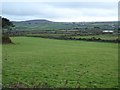
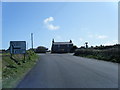
Farmland at High Bosavern
View across farmland at High Bosavern to the south of St Just.
Image: © Philip Halling
Taken: 6 Nov 2017
0.07 miles
4
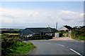
The B3306
A cyclist pushes up the hill to Higher Bosavern, near Lands End.
Image: © Robert Ashby
Taken: 20 Aug 2014
0.07 miles
5
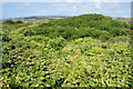
Is there a path here?
The scrubland on Carn Bosavern looks fairly impassable.
Image: © Bill Boaden
Taken: 11 Jul 2014
0.12 miles
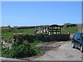
6
Reservoir on Carn Bosavern
This is no doubt the water supply for St Just.
Image: © Bill Boaden
Taken: 11 Jul 2014
0.12 miles
9
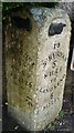
Milestone - Penzance 6.5
The OS cut mark on the milestone marks a point 147.2m above mean sea level.
Image: © Adrian Dust
Taken: 20 Feb 2017
0.15 miles
10
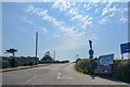
Cornwall : The B3306
A road heading off from the A3071.
Image: © Lewis Clarke
Taken: 21 Apr 2018
0.15 miles