IMAGES TAKEN NEAR TO
Kenython Lane, PENZANCE, TR19 7PT
Introduction
This page details the photographs taken nearby to Kenython Lane, TR19 7PT by members of the Geograph project.
The Geograph project started in 2005 with the aim of publishing, organising and preserving representative images for every square kilometre of Great Britain, Ireland and the Isle of Man.

There are currently over 7.5m images from over14,400 individuals and you can help contribute to the project by visiting https://www.geograph.org.uk
Image Map
Images are licensed for reuse under creativecommons.org/licenses/by-sa/2.0
Notes
- Clicking on the map will re-center to the selected point.
- The higher the marker number, the further away the image location is from the centre of the postcode.
Image Listing (5 Images Found)
Images are licensed for reuse under creativecommons.org/licenses/by-sa/2.0
Image
Details
Distance
1
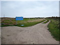
Farm track off Knave Go By Hill
In the distance on the left is the communications mast on Carn Bean Image
Image: © Rod Allday
Taken: 18 Sep 2009
0.20 miles
3
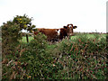
Heifer and hedge on No Go By hill
No-Go-By hill is the short cut from Tregeseal to Carnyorth. Much steeper than the usual, more seaward, route. So I think the name means 'only use in good weather'. I remember a similar name (None-go-byes) for a road near Cookridge in West Yorkshire Image Any others?
Image: © Sheila Russell
Taken: 8 Dec 2005
0.23 miles
4
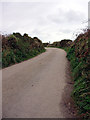
No Go By Hill
No-Go-By hill is the short cut from Tregeseal to Carnyorth. Much steeper than the usual, more seaward, route.
Image: © Sheila Russell
Taken: 8 Dec 2005
0.23 miles
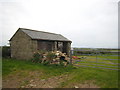
5
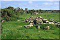
Gorse and Grass
The piles of rubble by the footpath look like granite pulled from the field or hedgerow.
Image: © Tony Atkin
Taken: 9 Sep 2009
0.24 miles