IMAGES TAKEN NEAR TO
Nancherrow, PENZANCE, TR19 7PR
Introduction
This page details the photographs taken nearby to Nancherrow, TR19 7PR by members of the Geograph project.
The Geograph project started in 2005 with the aim of publishing, organising and preserving representative images for every square kilometre of Great Britain, Ireland and the Isle of Man.

There are currently over 7.5m images from over14,400 individuals and you can help contribute to the project by visiting https://www.geograph.org.uk
Image Map
Images are licensed for reuse under creativecommons.org/licenses/by-sa/2.0
Notes
- Clicking on the map will re-center to the selected point.
- The higher the marker number, the further away the image location is from the centre of the postcode.
Image Listing (77 Images Found)
Images are licensed for reuse under creativecommons.org/licenses/by-sa/2.0
Image
Details
Distance
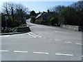
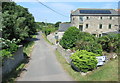
2
Tregaseal
Tregaseal is a settlement at a road junction in the valley north of St Just.
Image: © Tony Atkin
Taken: 4 Jul 2007
0.04 miles
3
Tregeseal : The B3306
From No Go By Hill looking along the B3306.
Image: © Lewis Clarke
Taken: 21 Apr 2018
0.04 miles
4
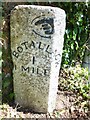
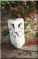
Old Milestone by the B3306 in Tregeseal
Carved stone post by the B3306, in parish of ST JUST (PENWITH District), Tregeseal, Nancherrow, 28m South of No 1 Trenhare, by the road. Stone fingerpost, erected by the parish in the 19th century.
Inscription reads:-
: {<-hand} / BOTALLACK / 1 / 1 MILE : : MORVAH / 4 / MILES :
Grade II listed.
List Entry Number: 1405980 https://historicengland.org.uk/listing/the-list/list-entry/1405980
Milestone Society National ID: CW_BOMO01.
Image: © Rosy Hanns
Taken: 4 Jul 2019
0.05 miles
5
Old Milestone by the B3306, Nancherrow
Carved stone post by the B3306, in parish of St Just (Penwith District), Tregeseal, Nancherrow, 28m South of No. 1 Trenhare, by the road. Stone fingerpost, erected by the parish in the 19th century.
Inscription reads:-
: {<-hand} / BOTALLACK / 1 / MILE : : {hand->} / MORVAH / 4 / MILES :
Grade II listed.
List Entry Number: 1405980 https://historicengland.org.uk/listing/the-list/list-entry/1405980
Milestone Society National ID: CW_BOMO01
Image: © Ian Thompson
Taken: Unknown
0.05 miles
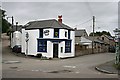
6
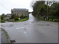
House on a road junction
House on a road junction at the bottom of Nancherrow Hill.
Image: © Philip Halling
Taken: 6 Nov 2017
0.05 miles
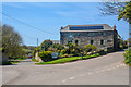
7
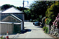
Not the best place to park a car
Coming down a steep hill towards a badly parked car on a minor road leading to Nancherro near St Just.
Image: © Robert Ashby
Taken: 20 Aug 2014
0.05 miles
8
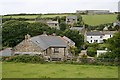
Tregaseal
The short stretch of road between Tregaseal and St Just is narrow and steep. The footpath through the fields is a handy alternative if you are walking.
Image: © Tony Atkin
Taken: 4 Jul 2007
0.07 miles
10
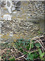
OS benchmark - St Just, Nancherrow Hill
An OS cutmark on the last building going north out of St Just (a garage or outhouse) which was originally levelled in 1972 at 119.209m above Ordnance Datum Newlyn.
Image: © Richard Law
Taken: 29 Dec 2015
0.12 miles