IMAGES TAKEN NEAR TO
Tregeseal, PENZANCE, TR19 7PG
Introduction
This page details the photographs taken nearby to Tregeseal, TR19 7PG by members of the Geograph project.
The Geograph project started in 2005 with the aim of publishing, organising and preserving representative images for every square kilometre of Great Britain, Ireland and the Isle of Man.

There are currently over 7.5m images from over14,400 individuals and you can help contribute to the project by visiting https://www.geograph.org.uk
Image Map
Images are licensed for reuse under creativecommons.org/licenses/by-sa/2.0
Notes
- Clicking on the map will re-center to the selected point.
- The higher the marker number, the further away the image location is from the centre of the postcode.
Image Listing (7 Images Found)
Images are licensed for reuse under creativecommons.org/licenses/by-sa/2.0
Image
Details
Distance
2
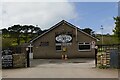
St Just Rugby Club
St Just Rugby Club, clubhouse with pitch behind it.
Image: © Elizabeth Scott
Taken: 13 Apr 2023
0.15 miles
3
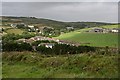
The Upper Kenidjack Valley
Taken from the footpath from Tregaseal to St Just church this shot shows eastern end of Tregaseal spreading out along the valley.
Image: © Tony Atkin
Taken: 4 Jul 2007
0.19 miles
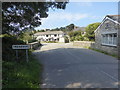
4
Tregaseal
The short stretch of road between Tregaseal and St Just is narrow and steep. The footpath through the fields is a handy alternative if you are walking.
Image: © Tony Atkin
Taken: 4 Jul 2007
0.21 miles
5
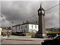
War memorial
War memorial, looking towards St Just village square
Image: © Richard Johns
Taken: 18 May 2005
0.21 miles
6
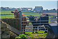
Cornwall : Grassy Field & Cattle
Cows take a nose at the photographer.
Image: © Lewis Clarke
Taken: 21 Apr 2018
0.22 miles
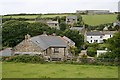
7
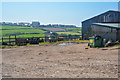
Cornwall : Farm Buildings
Farm buildings in Cornwall off of the road.
Image: © Lewis Clarke
Taken: 21 Apr 2018
0.22 miles