IMAGES TAKEN NEAR TO
Cape Close, PENZANCE, TR19 7PB
Introduction
This page details the photographs taken nearby to Cape Close, TR19 7PB by members of the Geograph project.
The Geograph project started in 2005 with the aim of publishing, organising and preserving representative images for every square kilometre of Great Britain, Ireland and the Isle of Man.

There are currently over 7.5m images from over14,400 individuals and you can help contribute to the project by visiting https://www.geograph.org.uk
Image Map
Images are licensed for reuse under creativecommons.org/licenses/by-sa/2.0
Notes
- Clicking on the map will re-center to the selected point.
- The higher the marker number, the further away the image location is from the centre of the postcode.
Image Listing (20 Images Found)
Images are licensed for reuse under creativecommons.org/licenses/by-sa/2.0
Image
Details
Distance
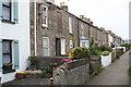
1
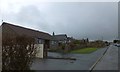
Bungalows on Cape Cornwall Road, St Just
Image: © David Smith
Taken: 18 Jan 2014
0.03 miles
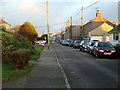
2
Cape Cornwall Road
Cape Cornwall Road heading into St Just
Image: © Shaun Ferguson
Taken: 28 May 2014
0.04 miles
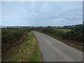
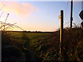
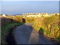
3
Entering St. Just along Cape Cornwall Road
Image: © John Lucas
Taken: 11 Jan 2012
0.07 miles
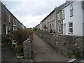
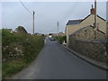
7
Princess Street St Just
St Just was a major mining town when tin mining was at its height and there are many streets like this with dense development of miners' cottages.
Image: © Rod Allday
Taken: 12 May 2009
0.13 miles
8
Approaching St. Just on the road from Carn Gloose
Image: © John Lucas
Taken: 11 Jan 2012
0.14 miles
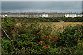
9
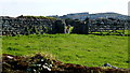
Llama or alpaca?
Whatever it is it's in a field by Bosorne Road, St. Just.
Carn Bosavern beyond.
Image: © Jonathan Billinger
Taken: 8 Sep 2012
0.18 miles