IMAGES TAKEN NEAR TO
Chapel Road, PENZANCE, TR19 7HT
Introduction
This page details the photographs taken nearby to Chapel Road, TR19 7HT by members of the Geograph project.
The Geograph project started in 2005 with the aim of publishing, organising and preserving representative images for every square kilometre of Great Britain, Ireland and the Isle of Man.

There are currently over 7.5m images from over14,400 individuals and you can help contribute to the project by visiting https://www.geograph.org.uk
Image Map
Images are licensed for reuse under creativecommons.org/licenses/by-sa/2.0
Notes
- Clicking on the map will re-center to the selected point.
- The higher the marker number, the further away the image location is from the centre of the postcode.
Image Listing (160 Images Found)
Images are licensed for reuse under creativecommons.org/licenses/by-sa/2.0
Image
Details
Distance
1
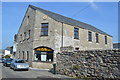
St Just Town Hall - Chapel Road
Pre 1900 artillery drill hall with artillery motif similar to Marazion.
Image: © John M
Taken: 9 Sep 2014
0.01 miles
2
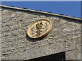
Artillery Motif on the Town Hall
Pre 1900 artillery drill hall with artillery motif similar to Marazion.
Image: © John M
Taken: 9 Sep 2014
0.01 miles
3
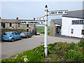
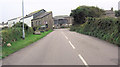
St Just : Chapel Road
Looking along Chapel Road from the B3306.
Image: © Lewis Clarke
Taken: 21 Apr 2018
0.01 miles
4
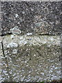
OS rivet - St Just, Methodist Church
An OS rivet on a ledge on the frontage of the church in Image; originally levelled in 1972 at 125.58m above Ordnance Datum Newlyn.
Image: © Richard Law
Taken: 29 Dec 2015
0.02 miles
5
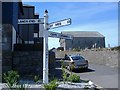
Old Direction Sign - Signpost by the B3306, Nancherrow Hill, St Just Parish
Pyramid finial - 3 arms; by the B3306, in parish of St Just (Penwith District), Nancherrow Hill, in flower bed at junction with Chapel Road.
To be surveyed
Milestone Society National ID: CW_SW3631.
Image: © Milestone Society
Taken: Unknown
0.02 miles
7
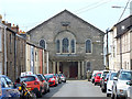
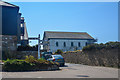
Methodist Church on Chapel Road, St Just
Image: © Gary Rogers
Taken: 26 May 2018
0.03 miles
8
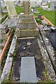
Grave of William Henry Tregear
One of the Levant Mine Disaster graves in the graveyard of the Wesleyan Methodist Chapel (also called the Miners' Chapel). In the disaster at nearby Levant tin and copper mine, 31 died on the 20th October 1919 when the "man engine" failed. Graves were restored as part of the centenary commemorations.
Image: © Elizabeth Scott
Taken: 13 Apr 2023
0.03 miles
10
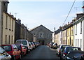
Wesleyan Methodist Chapel - St Just in Penwith
The chapel was completed in 1833 to seat 1,000 people. It is situated at the end of Chapel Street with its small terraced houses leading up to this imposing building.
Image: © Sarah Smith
Taken: 13 Apr 2010
0.03 miles