IMAGES TAKEN NEAR TO
Sennen, PENZANCE, TR19 7BJ
Introduction
This page details the photographs taken nearby to TR19 7BJ by members of the Geograph project.
The Geograph project started in 2005 with the aim of publishing, organising and preserving representative images for every square kilometre of Great Britain, Ireland and the Isle of Man.

There are currently over 7.5m images from over14,400 individuals and you can help contribute to the project by visiting https://www.geograph.org.uk
Image Map (Loading...)


Getting Data...Please wait
Leaflet Map data © OpenStreetMap
Images are licensed for reuse under creativecommons.org/licenses/by-sa/2.0
Notes
- Clicking on the map will re-center to the selected point.
- The higher the marker number, the further away the image location is from the centre of the postcode.
Image Listing (3 Images Found)
Images are licensed for reuse under creativecommons.org/licenses/by-sa/2.0
Image
Details
Distance
1
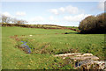
Penberth River near Penrose
Not far from its source, the Penberth River with an old granite footbridge.
Image: © Sheila Russell
Taken: 11 Jan 2006
0.13 miles
2
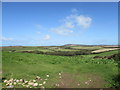
View across the valley towards Bartine Downs
The farmstead of Penrose is in the middle distance.
Image: © Matthew Hatton
Taken: 4 Sep 2019
0.13 miles