IMAGES TAKEN NEAR TO
The Wharf, PENZANCE, TR19 6RT
Introduction
This page details the photographs taken nearby to The Wharf, TR19 6RT by members of the Geograph project.
The Geograph project started in 2005 with the aim of publishing, organising and preserving representative images for every square kilometre of Great Britain, Ireland and the Isle of Man.

There are currently over 7.5m images from over14,400 individuals and you can help contribute to the project by visiting https://www.geograph.org.uk
Image Map
Images are licensed for reuse under creativecommons.org/licenses/by-sa/2.0
Notes
- Clicking on the map will re-center to the selected point.
- The higher the marker number, the further away the image location is from the centre of the postcode.
Image Listing (401 Images Found)
Images are licensed for reuse under creativecommons.org/licenses/by-sa/2.0
Image
Details
Distance
2
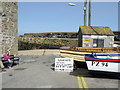
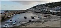
Access road to south quay car park, Mousehole
Image: © nick macneill
Taken: 8 Apr 2011
0.01 miles
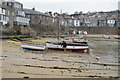
5

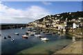
Mousehole: Harbour and Beach Scene
Image: © Mr Eugene Birchall
Taken: 21 Jul 2014
0.01 miles
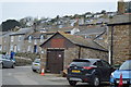
10
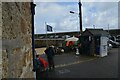
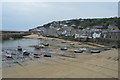
Penzance : Mousehole - The Wharf
Looking along The Wharf down by the harbour.
Image: © Lewis Clarke
Taken: 28 Sep 2022
0.02 miles