IMAGES TAKEN NEAR TO
Paul, PENZANCE, TR19 6NU
Introduction
This page details the photographs taken nearby to TR19 6NU by members of the Geograph project.
The Geograph project started in 2005 with the aim of publishing, organising and preserving representative images for every square kilometre of Great Britain, Ireland and the Isle of Man.

There are currently over 7.5m images from over14,400 individuals and you can help contribute to the project by visiting https://www.geograph.org.uk
Image Map (Loading...)


Getting Data...Please wait
Leaflet Map data © OpenStreetMap
Images are licensed for reuse under creativecommons.org/licenses/by-sa/2.0
Notes
- Clicking on the map will re-center to the selected point.
- The higher the marker number, the further away the image location is from the centre of the postcode.
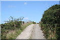
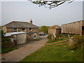
Image Listing (9 Images Found)
Images are licensed for reuse under creativecommons.org/licenses/by-sa/2.0
Image
Details
Distance
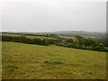
5
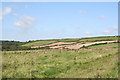
Fields at Bellowal
The area of woodland to the left of the picture is part of Trevider Moor.
Image: © Rod Allday
Taken: 27 Aug 2010
0.18 miles

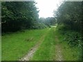
8
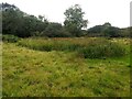
Wet ground and lots of rushes
Low lying fields don't drain very well.
Image: © David Medcalf
Taken: 7 Sep 2020
0.24 miles