IMAGES TAKEN NEAR TO
Paul, PENZANCE, TR19 6NS
Introduction
This page details the photographs taken nearby to TR19 6NS by members of the Geograph project.
The Geograph project started in 2005 with the aim of publishing, organising and preserving representative images for every square kilometre of Great Britain, Ireland and the Isle of Man.

There are currently over 7.5m images from over14,400 individuals and you can help contribute to the project by visiting https://www.geograph.org.uk
Image Map
Images are licensed for reuse under creativecommons.org/licenses/by-sa/2.0
Notes
- Clicking on the map will re-center to the selected point.
- The higher the marker number, the further away the image location is from the centre of the postcode.
Image Listing (5 Images Found)
Images are licensed for reuse under creativecommons.org/licenses/by-sa/2.0
Image
Details
Distance
1
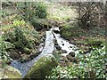
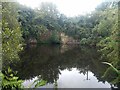
Tinner leat in Trevelloe woods
The leat is the best preserved feature of old tin streaming works that once ran down the stream in Trevelloe woods.
Image: © John Negus
Taken: Unknown
0.11 miles
3
Properties at Kerrisvean
Houses at Kerrisvean.
Image: © Elizabeth Scott
Taken: 16 Oct 2012
0.19 miles
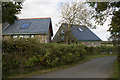
4
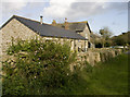
Former stables and house
The stables at Kerrisvean have been converted into living accommodation.
Image: © Elizabeth Scott
Taken: 16 Oct 2012
0.21 miles