IMAGES TAKEN NEAR TO
Lower Kemyell, PENZANCE, TR19 6NN
Introduction
This page details the photographs taken nearby to Lower Kemyell, TR19 6NN by members of the Geograph project.
The Geograph project started in 2005 with the aim of publishing, organising and preserving representative images for every square kilometre of Great Britain, Ireland and the Isle of Man.

There are currently over 7.5m images from over14,400 individuals and you can help contribute to the project by visiting https://www.geograph.org.uk
Image Map
Images are licensed for reuse under creativecommons.org/licenses/by-sa/2.0
Notes
- Clicking on the map will re-center to the selected point.
- The higher the marker number, the further away the image location is from the centre of the postcode.
Image Listing (12 Images Found)
Images are licensed for reuse under creativecommons.org/licenses/by-sa/2.0
Image
Details
Distance
1
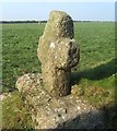
Old Wayside Cross - moved to Kemyel Drea, Paul parish
Kemyel Drea Cross, old head, neck and base, Langdon WP No.77 by the wayside, in parish of Paul (Penwith District), set against a hedge on a former church path, beside public footpath.
Grade II listed.
List Entry Number: 1143958 https://historicengland.org.uk/listing/the-list/list-entry/1143958
To be surveyed
Milestone Society National ID: CWPW_PAU08
Image: © Milestone Society
Taken: Unknown
0.02 miles
2
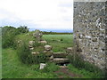
Cross and stile, Kemyel Drea
The 'Latin style' cross was apparently found leaning loose against a hedge, and was cemented into its current position in 1999 (ref. Archaeology Alive no. 8, Cornwall Archaeological Unit).
Image: © Tim Heaton
Taken: 27 Jun 2007
0.03 miles
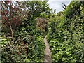
3
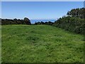
Field, but no path
The public footpath shown on the OS map is totally overgrown so the only route is through the field and, apparently, not often travelled.
Image: © David Medcalf
Taken: 6 Jun 2021
0.18 miles
4
A field near Kemyel Crease
A public footpath is shown on the OS map, crossing below the gate. It is impassable.
Image: © David Medcalf
Taken: 6 Jun 2021
0.19 miles
5
Path confusion
According to the OS map, the public footpath runs to the left of the fence, through the impenetrable scrub, but the stile leads into the field.
Image: © David Medcalf
Taken: 6 Jun 2021
0.19 miles
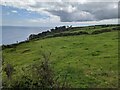
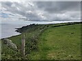
6
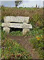
Millennium seat on the South West Coast Path
The path at this point is level.
Image: © Pauline E
Taken: 23 Apr 2008
0.21 miles
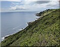
7
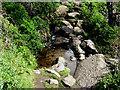
Stream running down to the sea
Cuts through the South West Coast Path.
Image: © Pauline E
Taken: 23 Apr 2008
0.21 miles
8
Fuchsia adds colour to the Coast Path
This is not a native plant, so how did it get here?
Image: © David Medcalf
Taken: 6 Jun 2021
0.22 miles
10
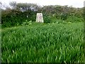
Raginnis Trig Point
Bagged after a walk through a number of maize fields using gates all the way as the field boundaries are almost impossible to cross.
Image: © Rude Health
Taken: 6 May 2015
0.23 miles