IMAGES TAKEN NEAR TO
Polgigga, PENZANCE, TR19 6LT
Introduction
This page details the photographs taken nearby to Polgigga, TR19 6LT by members of the Geograph project.
The Geograph project started in 2005 with the aim of publishing, organising and preserving representative images for every square kilometre of Great Britain, Ireland and the Isle of Man.

There are currently over 7.5m images from over14,400 individuals and you can help contribute to the project by visiting https://www.geograph.org.uk
Image Map
Images are licensed for reuse under creativecommons.org/licenses/by-sa/2.0
Notes
- Clicking on the map will re-center to the selected point.
- The higher the marker number, the further away the image location is from the centre of the postcode.
Image Listing (29 Images Found)
Images are licensed for reuse under creativecommons.org/licenses/by-sa/2.0
Image
Details
Distance
1
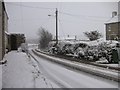
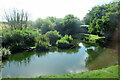
Snow at Polgigga
Looking down towards the duck pond.
Image: © Frances Watts
Taken: 2 Feb 2009
0.06 miles
2

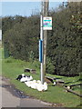
Village Pond, Polgigga
Next to the bus stop, buses run to Lands End and Penzance.
Image: © Hugh Venables
Taken: 28 Sep 2008
0.08 miles
3
Polgigga: geese wait for a bus
Birds form an orderly queue at a bus stop, although I think the pond just out of sight to the right is more likely relevant.
Image: © Chris Downer
Taken: 16 Oct 2013
0.10 miles
4
Duck pond and bus stop at Polgigga
The most south-westerly bus-stop in the UK, with buses between Lands End and Penzance.
Image: © Frances Watts
Taken: 5 Apr 2009
0.10 miles
5
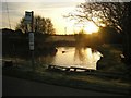
Looking over misty Polgigga
From the lane to Porthgwarra.
Image: © David Medcalf
Taken: 14 Jul 2008
0.11 miles
7
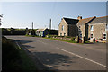
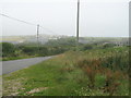
Polgigga
Junction between road to Lands End and Porthgwarra.
Image: © Hugh Venables
Taken: 28 Sep 2008
0.12 miles
8
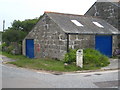
Milestone on the bend at Polgigga
On the B3315, which runs from Newlyn to Land's End.
Image: © Rod Allday
Taken: 28 May 2011
0.12 miles
9
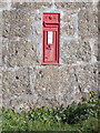
Polgigga: postbox № TR19 88
A Victorian postbox set into the wall of the building on the inside corner of the B3315.
Image: © Chris Downer
Taken: 16 Oct 2013
0.12 miles
10
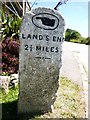
Old Milestone by the B3315 in Polgigga
Carved stone post by the B3315, in parish of ST LEVAN (PENWITH District), Polgigga, near Trethewey, at cross roads, on Northeast side of road. Stone fingerpost, erected by the parish in the 19th century.
Inscription reads:-
: {<-hand} / LAND'S END / 2½ MILES : : {hand->} / LOGAN ROCK / 1¾ MILES :
Grade II listed.
List Entry Number: 1138333 https://historicengland.org.uk/listing/the-list/list-entry/1138333
Milestone Society National ID: CW_LELR02.
Image: © Rosy Hanns
Taken: 5 Jul 2019
0.12 miles