IMAGES TAKEN NEAR TO
Porthcurno, PENZANCE, TR19 6JU
Introduction
This page details the photographs taken nearby to Porthcurno, TR19 6JU by members of the Geograph project.
The Geograph project started in 2005 with the aim of publishing, organising and preserving representative images for every square kilometre of Great Britain, Ireland and the Isle of Man.

There are currently over 7.5m images from over14,400 individuals and you can help contribute to the project by visiting https://www.geograph.org.uk
Image Map (Loading...)


Getting Data...Please wait
Leaflet Map data © OpenStreetMap
Images are licensed for reuse under creativecommons.org/licenses/by-sa/2.0
Notes
- Clicking on the map will re-center to the selected point.
- The higher the marker number, the further away the image location is from the centre of the postcode.
Image Listing (153 Images Found)
Images are licensed for reuse under creativecommons.org/licenses/by-sa/2.0
Image
Details
Distance
1
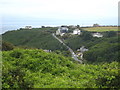
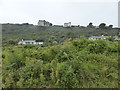
Porthcurno valley
Looking across the valley towards the road up to Minack Point, seen from the escape staircase exit at Porthcurno cable station Image
Image: © Rod Allday
Taken: 20 Jul 2011
0.02 miles
2
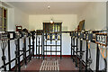
Inside Porthcurno Cable Hut
Porthcurno Cable Hut is where telegraph cables from all over the world terminated to be routed to UK destinations. Equipment in this hut enabled engineers to test the various cable circuits before they were routed to the Cable Station on the cliff behind.
Image: © Bob Walters
Taken: 29 May 2015
0.04 miles
3
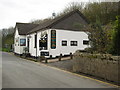
Cable Station Inn, Porthcurno
Inn in the centre of Porthcurno.
Image: © Philip Halling
Taken: 30 Apr 2010
0.04 miles
4
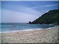
Porthcurno Beach
A rare nice day in June 2007
Image: © Paul Marsh
Taken: 25 Jun 2007
0.04 miles
5
Bungalows, houses and apartments at Porthcurno
The full range of housing in a rural setting.
Image: © David Medcalf
Taken: 3 Sep 2014
0.05 miles
6
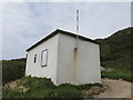
The concrete cable hut, Porthcurno
This is where the cable shore ends from the British termination of early submarine telegraph cables were connected to their respective landlines. It is a listed building and stands at the top of the beach.
Image: © Richard Rogerson
Taken: 4 Jul 2012
0.06 miles
7
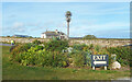
Palm Tree near the Exit
The way out from the Minack Theatre, with Minack Lodge in the background.
Image: © Des Blenkinsopp
Taken: 29 Sep 2020
0.07 miles
8
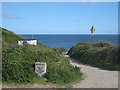
The path to the beach at Porthcurno
There is much of relevance in this picture: The South West Coastal Path crosses this path, as evidenced on the granite signpost - Penberth to the left and Porthgwarra to the right; the diamond-shaped sign indicates the presence of underground cables, of which there are many buried under the beach, this place being the landfall of many cables under the Atlantic Ocean and the small building houses the terminals of these cables.
Image: © Rod Allday
Taken: 3 May 2009
0.09 miles
9
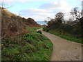
Footpath from the Car Park to the Beach at Porth Curnow
Image: © Bill Henderson
Taken: 20 Dec 2009
0.09 miles
10
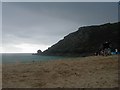
Looking out at the storm clouds approaching
This photograph was taken just before a tremendous thunderstorm complete with lightning that cleared the beach of all but hardy holiday makers!
Image: © Susan Tromans
Taken: 14 Aug 2006
0.09 miles