IMAGES TAKEN NEAR TO
St. Buryan, PENZANCE, TR19 6JB
Introduction
This page details the photographs taken nearby to TR19 6JB by members of the Geograph project.
The Geograph project started in 2005 with the aim of publishing, organising and preserving representative images for every square kilometre of Great Britain, Ireland and the Isle of Man.

There are currently over 7.5m images from over14,400 individuals and you can help contribute to the project by visiting https://www.geograph.org.uk
Image Map
Images are licensed for reuse under creativecommons.org/licenses/by-sa/2.0
Notes
- Clicking on the map will re-center to the selected point.
- The higher the marker number, the further away the image location is from the centre of the postcode.
Image Listing (10 Images Found)
Images are licensed for reuse under creativecommons.org/licenses/by-sa/2.0
Image
Details
Distance
1
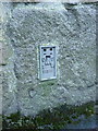
OS flush bracket at Brea Farm
Flush Bracket 11811 in the wall of a converted outbuilding at Brea Farm; originally levelled at 121.24m above Ordnance Datum Newlyn.
Image: © Richard Law
Taken: 25 Dec 2013
0.02 miles
2
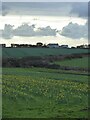
Ruined building and road at Brea Farm
The former barn or whatever lay in ruins in 2012. I passed this way again just after Christmas 2015, and it's now been demolished.
Image: © Richard Law
Taken: 26 Dec 2012
0.03 miles
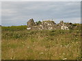
3
Buildings at Brea Farm
On a misty day! There seem to be several different dwelling houses on the farm site.
Image: © David Medcalf
Taken: 8 Sep 2009
0.04 miles
5
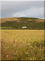
Field of ripe wheat below Chapel Carn Brea
Image: © Rod Allday
Taken: 16 Jul 2008
0.08 miles
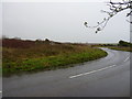
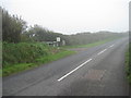
7
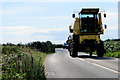
The B3306
A Really Big Truck. Not for playing chicken with!
Image: © Robert Ashby
Taken: 20 Aug 2014
0.17 miles
8
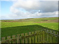
The shallow valley of the Nanjulian River
The small Nanjulian River (if that's the right name for it) rises on the slopes of Carn Brea just east of here, and flows northwestwards down this shallow valley, passing Brea Farm, Nanquidno and Nanjulian, to drop down the cliffs and into the sea at Maen Dower in Image
Image: © Richard Law
Taken: 25 Dec 2012
0.21 miles
9
The entrance to Kerrow farm
On the B3306.
Image: © David Medcalf
Taken: 8 Sep 2009
0.22 miles
10
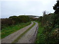
The track to Kerrow Farm
On a rather dull, soon to be wet, afternoon.
Image: © Richard Law
Taken: 26 Dec 2012
0.24 miles