IMAGES TAKEN NEAR TO
St. Buryan, PENZANCE, TR19 6HY
Introduction
This page details the photographs taken nearby to TR19 6HY by members of the Geograph project.
The Geograph project started in 2005 with the aim of publishing, organising and preserving representative images for every square kilometre of Great Britain, Ireland and the Isle of Man.

There are currently over 7.5m images from over14,400 individuals and you can help contribute to the project by visiting https://www.geograph.org.uk
Image Map
Images are licensed for reuse under creativecommons.org/licenses/by-sa/2.0
Notes
- Clicking on the map will re-center to the selected point.
- The higher the marker number, the further away the image location is from the centre of the postcode.
Image Listing (4 Images Found)
Images are licensed for reuse under creativecommons.org/licenses/by-sa/2.0
Image
Details
Distance
2
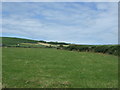
Grazing near Crows-an-wra
Looking north from the A30.
Image: © JThomas
Taken: 13 Jul 2017
0.20 miles
4
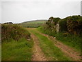
Lane to Crows-an-wra
St Buryan church tower can be seen in the distance.
Image: © Row17
Taken: 31 Jul 2008
0.24 miles