IMAGES TAKEN NEAR TO
St. Buryan, PENZANCE, TR19 6HG
Introduction
This page details the photographs taken nearby to TR19 6HG by members of the Geograph project.
The Geograph project started in 2005 with the aim of publishing, organising and preserving representative images for every square kilometre of Great Britain, Ireland and the Isle of Man.

There are currently over 7.5m images from over14,400 individuals and you can help contribute to the project by visiting https://www.geograph.org.uk
Image Map (Loading...)


Getting Data...Please wait
Leaflet Map data © OpenStreetMap
Images are licensed for reuse under creativecommons.org/licenses/by-sa/2.0
Notes
- Clicking on the map will re-center to the selected point.
- The higher the marker number, the further away the image location is from the centre of the postcode.
Image Listing (9 Images Found)
Images are licensed for reuse under creativecommons.org/licenses/by-sa/2.0
Image
Details
Distance
3
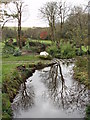
Stream at Alsia Mill
Once the mill stream, now part of a formal garden.
Image: © Sheila Russell
Taken: 17 Nov 2005
0.18 miles
4
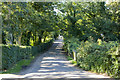
Access to Higher Alsia Farm
Access lane to Higher Alsia Farm
Image: © Elizabeth Scott
Taken: 3 Sep 2013
0.18 miles
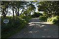
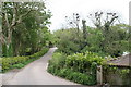
5
Road at Alsia Mill
The property with the white gate is now called Alsia Wells.
Image: © Elizabeth Scott
Taken: 3 Sep 2013
0.19 miles
7
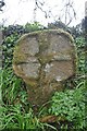
Old Wayside Cross
Alsia Cross, a wayside cross with an old head and neck. Set on the south side of the road at Lower Alsia in St Buryan parish. Grade II Listed https://historicengland.org.uk/listing/the-list/list-entry/1143913. See also http://www.flickr.com/photos/ocifant/2478925706.
Milestone Society National ID: CWPW_SBU06
Image: © L Nott
Taken: 14 Mar 2020
0.20 miles
8
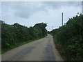
National Cycle Route 3, Alsia
Looking north west.
Image: © JThomas
Taken: 13 Jul 2017
0.20 miles
9
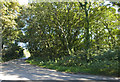
Roadside wooded area
Roadside wooded area opposite the entrance to Higher Alsia Farm.
Image: © Elizabeth Scott
Taken: 3 Sep 2013
0.22 miles