IMAGES TAKEN NEAR TO
Crean, PENZANCE, TR19 6HA
Introduction
This page details the photographs taken nearby to Crean, TR19 6HA by members of the Geograph project.
The Geograph project started in 2005 with the aim of publishing, organising and preserving representative images for every square kilometre of Great Britain, Ireland and the Isle of Man.

There are currently over 7.5m images from over14,400 individuals and you can help contribute to the project by visiting https://www.geograph.org.uk
Image Map
Images are licensed for reuse under creativecommons.org/licenses/by-sa/2.0
Notes
- Clicking on the map will re-center to the selected point.
- The higher the marker number, the further away the image location is from the centre of the postcode.
Image Listing (4 Images Found)
Images are licensed for reuse under creativecommons.org/licenses/by-sa/2.0
Image
Details
Distance
1
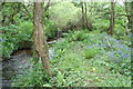
Stream below Crean Mill
A pretty sight with lots of bluebells in the woods.
Image: © Rod Allday
Taken: 12 May 2009
0.06 miles
3
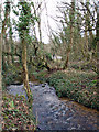
Mill stream at Crean Mill
Looking north east towards the road at Crean Mill. The same stream system also supported Alsia Mill, a little way upstream Image
Image: © Sheila Russell
Taken: 14 Jan 2006
0.11 miles