IMAGES TAKEN NEAR TO
St. Buryan, PENZANCE, TR19 6EE
Introduction
This page details the photographs taken nearby to TR19 6EE by members of the Geograph project.
The Geograph project started in 2005 with the aim of publishing, organising and preserving representative images for every square kilometre of Great Britain, Ireland and the Isle of Man.

There are currently over 7.5m images from over14,400 individuals and you can help contribute to the project by visiting https://www.geograph.org.uk
Image Map (Loading...)


Getting Data...Please wait
Leaflet Map data © OpenStreetMap
Images are licensed for reuse under creativecommons.org/licenses/by-sa/2.0
Notes
- Clicking on the map will re-center to the selected point.
- The higher the marker number, the further away the image location is from the centre of the postcode.
Image Listing (7 Images Found)
Images are licensed for reuse under creativecommons.org/licenses/by-sa/2.0
Image
Details
Distance
1
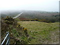
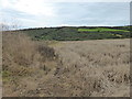
Alongside the B3283
The road passes through low moorland countryside north of St Buryans. View south-west towards Land's End.
Image: © Jonathan Billinger
Taken: 2 Apr 2008
0.10 miles
2
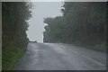
Drift : Penzance Road
Looking along a country road.
Image: © Lewis Clarke
Taken: 30 Sep 2022
0.12 miles
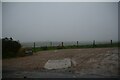
3
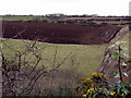
Winter fields near Catchall
The farm buildings are Trenuggo. A scattering of snow fell last night and can be seen in the ploughed field, along with the seagulls.
Image: © Sheila Russell
Taken: 2 Mar 2006
0.14 miles
6
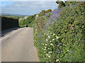
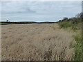
Hedgerow flowers alongside the B3283
Cow Parsley, Red Campion, Bluebells, Lesser Stitchwort and Sorrel, with Hawthorn blossom in the distance.
Image: © Rod Allday
Taken: 23 May 2009
0.20 miles
7
Drift : Driveway
A driveway off Penzance Road.
Image: © Lewis Clarke
Taken: 30 Sep 2022
0.23 miles