IMAGES TAKEN NEAR TO
Kew Pendra, PENZANCE, TR19 6DW
Introduction
This page details the photographs taken nearby to Kew Pendra, TR19 6DW by members of the Geograph project.
The Geograph project started in 2005 with the aim of publishing, organising and preserving representative images for every square kilometre of Great Britain, Ireland and the Isle of Man.

There are currently over 7.5m images from over14,400 individuals and you can help contribute to the project by visiting https://www.geograph.org.uk
Image Map
Images are licensed for reuse under creativecommons.org/licenses/by-sa/2.0
Notes
- Clicking on the map will re-center to the selected point.
- The higher the marker number, the further away the image location is from the centre of the postcode.
Image Listing (98 Images Found)
Images are licensed for reuse under creativecommons.org/licenses/by-sa/2.0
Image
Details
Distance
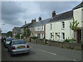
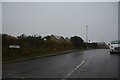
1
St Buryan : Kew Pendra
Looking along Kew Pendra.
Image: © Lewis Clarke
Taken: 30 Sep 2022
0.03 miles
2
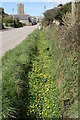
Ditch beside the road through the village
Lesser Celandine is growing profusely in the ditch beside the road through St. Buryan.
Image: © Elizabeth Scott
Taken: 8 Apr 2010
0.05 miles
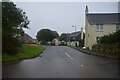
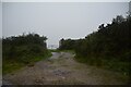
3
St Buryan : Kew Pendra
A footpath off the road.
Image: © Lewis Clarke
Taken: 30 Sep 2022
0.05 miles
4
St Buryan : Parc-An-Pearth
Looking along a road.
Image: © Lewis Clarke
Taken: 30 Sep 2022
0.07 miles
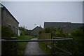
5
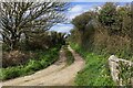
St Buryan : Track
A track up to a gate off the B3283.
Image: © Lewis Clarke
Taken: 30 Sep 2022
0.08 miles
6
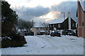
Snowy St. Buryan
Houses at Kew Pendra in St. Buryan village after overnight snow.
Image: © Elizabeth Scott
Taken: 6 Jan 2010
0.08 miles
7
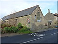
St Buryan village hall
On the Lands End road, this building was erected in 1830 and originally served as the village school up until a new one was built in Rectory Road in 1910.
Image: © Richard Law
Taken: 24 Dec 2015
0.09 miles
8
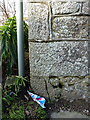
OS benchmark - St Buryan, village hall
An OS cutmark on a cornerstone of the village hall, which was once a school building; originally levelled at 118.049m above Ordnance Datum Newlyn.
Image: © Richard Law
Taken: 24 Dec 2015
0.09 miles
9
Boskennal Lane
Boskennal Lane, looking back towards the village.
Image: © Elizabeth Scott
Taken: 3 Apr 2023
0.10 miles