IMAGES TAKEN NEAR TO
Boskennal, PENZANCE, TR19 6DR
Introduction
This page details the photographs taken nearby to Boskennal, TR19 6DR by members of the Geograph project.
The Geograph project started in 2005 with the aim of publishing, organising and preserving representative images for every square kilometre of Great Britain, Ireland and the Isle of Man.

There are currently over 7.5m images from over14,400 individuals and you can help contribute to the project by visiting https://www.geograph.org.uk
Image Map
Images are licensed for reuse under creativecommons.org/licenses/by-sa/2.0
Notes
- Clicking on the map will re-center to the selected point.
- The higher the marker number, the further away the image location is from the centre of the postcode.
Image Listing (2 Images Found)
Images are licensed for reuse under creativecommons.org/licenses/by-sa/2.0
Image
Details
Distance
1
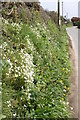
Hedgerow near Bosliven
The hedgerow is full of spring flowers. The white sign on the distant post directs to Bosliven Farm, which is down a short lane on the left.
Image: © Elizabeth Scott
Taken: 14 Apr 2009
0.17 miles
2
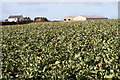
Cauliflower field
I followed the footpath through Boskennal and along a couple of field-edges then I was able to take this shot of the cauliflower field with the buildings of Boskennal Farm distant.
Image: © Elizabeth Scott
Taken: 28 Feb 2010
0.23 miles