IMAGES TAKEN NEAR TO
St. Buryan, PENZANCE, TR19 6BS
Introduction
This page details the photographs taken nearby to TR19 6BS by members of the Geograph project.
The Geograph project started in 2005 with the aim of publishing, organising and preserving representative images for every square kilometre of Great Britain, Ireland and the Isle of Man.

There are currently over 7.5m images from over14,400 individuals and you can help contribute to the project by visiting https://www.geograph.org.uk
Image Map
Images are licensed for reuse under creativecommons.org/licenses/by-sa/2.0
Notes
- Clicking on the map will re-center to the selected point.
- The higher the marker number, the further away the image location is from the centre of the postcode.
Image Listing (20 Images Found)
Images are licensed for reuse under creativecommons.org/licenses/by-sa/2.0
Image
Details
Distance
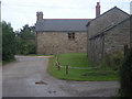
3
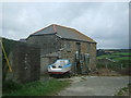
Farm buildings and conversions at Tregadgwith
Image: © Richard Law
Taken: 26 Dec 2015
0.01 miles
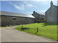
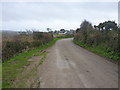
6
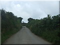
Lane, Tregadgwith
Looking south west up the hill.
Image: © JThomas
Taken: 13 Jul 2017
0.05 miles
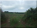
8

Fields at Tregadgwith
Looking up the valley towards Trevorrian Farm.
Image: © Rod Allday
Taken: 17 Sep 2008
0.09 miles
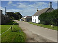
9
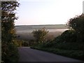
Just past Tregadgwith
Early on a misty autumn morning.
Image: © Frances Watts
Taken: 7 Sep 2007
0.09 miles
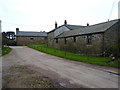
10
Newlyn Road at Tregadgwith
The narrow lane eastwards out of St Buryan passes through the two farms at Tregadgwith just around this corner.
Image: © Richard Law
Taken: 26 Dec 2015
0.11 miles