IMAGES TAKEN NEAR TO
Buryas Bridge, PENZANCE, TR19 6AU
Introduction
This page details the photographs taken nearby to TR19 6AU by members of the Geograph project.
The Geograph project started in 2005 with the aim of publishing, organising and preserving representative images for every square kilometre of Great Britain, Ireland and the Isle of Man.

There are currently over 7.5m images from over14,400 individuals and you can help contribute to the project by visiting https://www.geograph.org.uk
Image Map
Images are licensed for reuse under creativecommons.org/licenses/by-sa/2.0
Notes
- Clicking on the map will re-center to the selected point.
- The higher the marker number, the further away the image location is from the centre of the postcode.
Image Listing (13 Images Found)
Images are licensed for reuse under creativecommons.org/licenses/by-sa/2.0
Image
Details
Distance
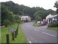
2
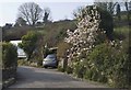
Bridleway at Buryas Bridge
This bridleway leads to Higher Bologgas and also to Tredavoe. In the garden of the house next to the bridleway there is a beautiful magnolia.
Image: © Elizabeth Scott
Taken: 26 Mar 2012
0.02 miles
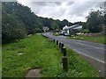
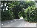
5
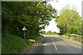
Buryas Bridge : A30
Looking along the A30.
Image: © Lewis Clarke
Taken: 29 Sep 2022
0.08 miles
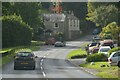
7
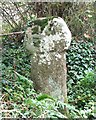
Trembath Cross
This unusual granite cross stands beside the A30 Land's End road not far from Penzance.
Image: © Malcolm Kewn
Taken: 3 Oct 2006
0.09 miles
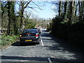
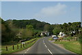
8
A30 towards Land's End
Looking south west down the hill from the entrance to Trewidden Gardens.
Image: © JThomas
Taken: 13 Jul 2017
0.10 miles