IMAGES TAKEN NEAR TO
The Strand, PENZANCE, TR18 5HJ
Introduction
This page details the photographs taken nearby to The Strand, TR18 5HJ by members of the Geograph project.
The Geograph project started in 2005 with the aim of publishing, organising and preserving representative images for every square kilometre of Great Britain, Ireland and the Isle of Man.

There are currently over 7.5m images from over14,400 individuals and you can help contribute to the project by visiting https://www.geograph.org.uk
Image Map
Images are licensed for reuse under creativecommons.org/licenses/by-sa/2.0
Notes
- Clicking on the map will re-center to the selected point.
- The higher the marker number, the further away the image location is from the centre of the postcode.
Image Listing (222 Images Found)
Images are licensed for reuse under creativecommons.org/licenses/by-sa/2.0
Image
Details
Distance
3
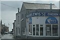
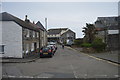
Penzance : Newlyn - The Strand
The Strand and Lewis's Fish & Chips.
Image: © Lewis Clarke
Taken: 28 Sep 2022
0.01 miles
8
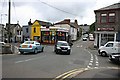
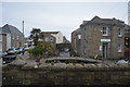
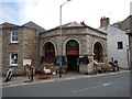
Road Junction at the Centre of Newlyn
During the height of the Summer tourist season this junction can be at the heart of a lot of traffic chaos.
Image: © Tony Atkin
Taken: 19 Jul 2007
0.01 miles