IMAGES TAKEN NEAR TO
Tredavoe Lane, PENZANCE, TR18 5DL
Introduction
This page details the photographs taken nearby to Tredavoe Lane, TR18 5DL by members of the Geograph project.
The Geograph project started in 2005 with the aim of publishing, organising and preserving representative images for every square kilometre of Great Britain, Ireland and the Isle of Man.

There are currently over 7.5m images from over14,400 individuals and you can help contribute to the project by visiting https://www.geograph.org.uk
Image Map
Images are licensed for reuse under creativecommons.org/licenses/by-sa/2.0
Notes
- Clicking on the map will re-center to the selected point.
- The higher the marker number, the further away the image location is from the centre of the postcode.
Image Listing (32 Images Found)
Images are licensed for reuse under creativecommons.org/licenses/by-sa/2.0
Image
Details
Distance
1
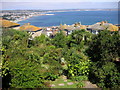
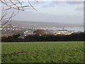
Mount's Bay, West Cornwall
The broad sweep of Mount's Bay as seen from the top of the hill in Newlyn. St Michael's Mount is visible on the right; Trencrom Hill on the skyline to the left; Penzance's Art Deco bathing pool, and St Mary's Church on the headland; Newlyn Harbour between the houses.
Image: © Frances Watts
Taken: 3 Aug 2006
0.08 miles
2
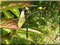
Golden-ringed Dragonfly
This huge golden-ringed dragonfly obligingly posed for photographs while it ate a wasp. The wasp gives an idea of just how big the dragonfly was.
Image: © Frances Watts
Taken: 14 Jul 2007
0.08 miles
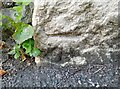
3
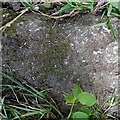
Ordnance Survey Rivet
This OS rivet can be found on the stile. It marks a point 94.227m above mean sea level.
Image: © Adrian Dust
Taken: 5 Jun 2024
0.09 miles
4
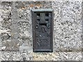
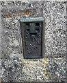
Ordnance Survey Flush Bracket 1575
This bracket can be found on the wall of Newlyn School of Art. The benchmark height is recorded as being 68.531 metres above sea level.
For more detail see : http://www.bench-marks.org.uk/bm1224
Image: © Peter Wood
Taken: 1 May 2017
0.13 miles
5
Ordnance Survey Flush Bracket (1574)
This OS Flush Bracket can be found on the school. It marks a point 68.531m above mean sea level.
Image: © Adrian Dust
Taken: 5 Jun 2024
0.14 miles
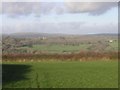
6
From the footpath between Newlyn and Tredavoe
Farmland, just outside Newlyn. St Mary's Church, Penzance, is on the headland. Trencrom Hill is just visible on the left-hand skyline.
Image: © Frances Watts
Taken: 26 Jan 2008
0.14 miles
8
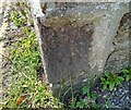
Ordnance Survey Cut Mark
This OS cut mark can be found on the wall of No1 Parc Terrace. It marks a point 52.164m above mean sea level.
Image: © Adrian Dust
Taken: 5 Jun 2024
0.15 miles
9
Ordnance Survey Cut Mark
This OS cut mark can be found on The Coach House. It marks a point 42.878m above mean sea level.
Image: © Adrian Dust
Taken: 5 Jun 2024
0.16 miles
10
Farmland near Tredavoe
From the footpath between Newlyn and Tredavoe. The meadowland at trewidden and Trereife is visible; also (to the far left) Sancreed.
Image: © Frances Watts
Taken: 26 Jan 2008
0.18 miles