IMAGES TAKEN NEAR TO
Tredarvah Road, PENZANCE, TR18 4LE
Introduction
This page details the photographs taken nearby to Tredarvah Road, TR18 4LE by members of the Geograph project.
The Geograph project started in 2005 with the aim of publishing, organising and preserving representative images for every square kilometre of Great Britain, Ireland and the Isle of Man.

There are currently over 7.5m images from over14,400 individuals and you can help contribute to the project by visiting https://www.geograph.org.uk
Image Map
Images are licensed for reuse under creativecommons.org/licenses/by-sa/2.0
Notes
- Clicking on the map will re-center to the selected point.
- The higher the marker number, the further away the image location is from the centre of the postcode.
Image Listing (27 Images Found)
Images are licensed for reuse under creativecommons.org/licenses/by-sa/2.0
Image
Details
Distance
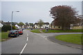
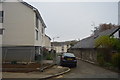
1
Penzance : Road
A road heads through Penzance.
Image: © Lewis Clarke
Taken: 28 Sep 2022
0.08 miles
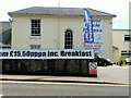
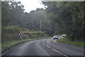
3

Penzance : The Pirate Inn
The Pirate Inn in Penzance.
Image: © Lewis Clarke
Taken: 28 Sep 2022
0.10 miles
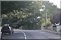
7
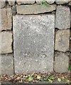
Western limits
1865 boundary stone marking the western edge of Penzance. This stone replaced the original of 1687 removed when an estate wall was altered.
Image: © Malcolm Kewn
Taken: 17 Feb 2009
0.13 miles
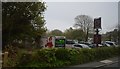
8
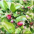
Polgoon apple orchard
Apples forming on trees in the Polgoon vineyard and orchard
Image: © Mike Jackson
Taken: 17 Jun 2016
0.13 miles