IMAGES TAKEN NEAR TO
Coulsons Place, PENZANCE, TR18 4DY
Introduction
This page details the photographs taken nearby to Coulsons Place, TR18 4DY by members of the Geograph project.
The Geograph project started in 2005 with the aim of publishing, organising and preserving representative images for every square kilometre of Great Britain, Ireland and the Isle of Man.

There are currently over 7.5m images from over14,400 individuals and you can help contribute to the project by visiting https://www.geograph.org.uk
Image Map
Images are licensed for reuse under creativecommons.org/licenses/by-sa/2.0
Notes
- Clicking on the map will re-center to the selected point.
- The higher the marker number, the further away the image location is from the centre of the postcode.
Image Listing (578 Images Found)
Images are licensed for reuse under creativecommons.org/licenses/by-sa/2.0
Image
Details
Distance
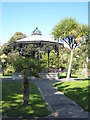
2
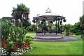
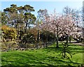
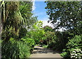
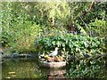
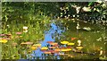
Morrab Gardens - Penzance
A fine sub tropical garden in the centre of Penzance.
Image: © Richard Knights
Taken: 30 Jul 2005
0.02 miles
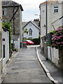
7
The Maldens
Grade II listed. https://historicengland.org.uk/listing/the-list/list-entry/1143953
Image: © N Chadwick
Taken: 9 Sep 2018
0.04 miles
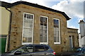
10
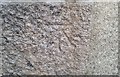
Ordnance Survey Cut Mark
This OS cut mark can be found on the old school building. It marks a point 15.4900m above mean sea level.
Image: © Adrian Dust
Taken: 23 Feb 2017
0.05 miles