IMAGES TAKEN NEAR TO
Brookward Terrace, PENZANCE, TR18 3QZ
Introduction
This page details the photographs taken nearby to Brookward Terrace, TR18 3QZ by members of the Geograph project.
The Geograph project started in 2005 with the aim of publishing, organising and preserving representative images for every square kilometre of Great Britain, Ireland and the Isle of Man.

There are currently over 7.5m images from over14,400 individuals and you can help contribute to the project by visiting https://www.geograph.org.uk
Image Map
Images are licensed for reuse under creativecommons.org/licenses/by-sa/2.0
Notes
- Clicking on the map will re-center to the selected point.
- The higher the marker number, the further away the image location is from the centre of the postcode.
Image Listing (15 Images Found)
Images are licensed for reuse under creativecommons.org/licenses/by-sa/2.0
Image
Details
Distance
1
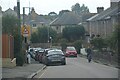
Madron Road, Heamoor
Heamoor is a suburb on the northern fringe of Penzance. This photo shows what look like late 19th century terraces lining the road through Heamoor. More modern housing development on either side of this road has turned a 19th century village into a 21st century suburb.
Image: © Tony Atkin
Taken: 19 Jul 2007
0.03 miles
2
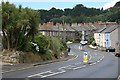
Penzance : Madron Road
Looking along a residential road.
Image: © Lewis Clarke
Taken: 29 Sep 2022
0.03 miles
3
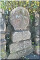
Old Wayside Cross
Heamoor Cross, a wayside cross with an old head & base. Set beside the B3312 in Heamoor Village. Madron parish. Langdon WP No.63. See also http://www.flickr.com/photos/38116967@N04/4036940550 and http://www.flickr.com/photos/ocifant/2951172815.
Milestone Society National ID: CWPW_MAD04
Image: © L Nott
Taken: 18 Oct 2019
0.05 miles
4
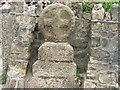
Village Cross
Granite cross in Heamoor, opposite the Sportsman's Arms.
Image: © Malcolm Kewn
Taken: 15 Aug 2006
0.05 miles
5
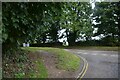
Penzance : B3312
Looking along the B3312 from Boscathnoe Lane.
Image: © Lewis Clarke
Taken: 28 Sep 2022
0.06 miles
6
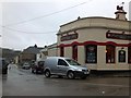
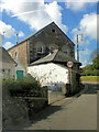
The Sportsman's Arms, Heamoor
An inn on a crossroads in Heamoor, with distinctive architecture
Image: © David Smith
Taken: 21 Mar 2013
0.06 miles
7
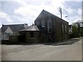
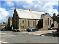
Former Bible Christian Chapel, Heamoor
Now a private dwelling. Flush bracket G1991 can be found on this church.
Image: © Rude Health
Taken: 6 May 2015
0.13 miles
9
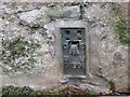
Ordnance Survey Flush Bracket G1991
This bracket can be found on the roadside wall of a building in Heamoor. The benchmark height is recorded as being 50.603 metres above sea level.
For more detail see : http://www.bench-marks.org.uk/bm14103
Image: © Peter Wood
Taken: 1 May 2017
0.14 miles